Monthly average daily temperatures in the United Kingdom 2015-2024
- statista.com
Updated Dec 15, 2024 Share
Share Facebook
 Twitter
 EmailClick to copy linkLink copiedCiteStatista (2024). Monthly average daily temperatures in the United Kingdom 2015-2024 [Dataset]. https://www.statista.com/statistics/322658/monthly-average-daily-temperatures-in-the-united-kingdom-uk/Dataset updatedDec 15, 2024Time period coveredJan 2015 - Nov 2024Area coveredUnited KingdomDescription
The highest average temperature recorded in 2024 until November was in August, at 16.8 degrees Celsius. Since 2015, the highest average daily temperature in the UK was registered in July 2018, at 18.7 degrees Celsius. The summer of 2018 was the joint hottest since institutions began recording temperatures in 1910. One noticeable anomaly during this period was in December 2015, when the average daily temperature reached 9.5 degrees Celsius. This month also experienced the highest monthly rainfall in the UK since before 2014, with England, Wales, and Scotland suffering widespread flooding. Daily hours of sunshine Unsurprisingly, the heat wave that spread across the British Isles in 2018 was the result of particularly sunny weather. July 2018 saw an average of 8.7 daily sun hours in the United Kingdom. This was more hours of sun than was recorded in July 2024, which only saw 5.8 hours of sun. Temperatures are on the rise Since the 1960s, there has been an increase in regional temperatures across the UK. Between 1961 and 1990, temperatures in England averaged nine degrees Celsius, and from 2013 to 2022, average temperatures in the country had increased to 10.3 degrees Celsius. Due to its relatively southern location, England continues to rank as the warmest country in the UK.
Monthly mean temperature in England 2015-2025
- statista.com
Updated Oct 15, 2025ShareFacebookTwitterEmailClick to copy linkLink copiedCiteStatista (2025). Monthly mean temperature in England 2015-2025 [Dataset]. https://www.statista.com/statistics/585133/monthly-mean-temperature-in-england-uk/Dataset updatedOct 15, 2025Time period coveredJan 2015 - Sep 2025Area coveredUnited Kingdom, EnglandDescriptionEngland's highest monthly mean air temperatures are typically recorded in July and August of each year. Since 2015, the warmest mean temperature was measured in July 2018 at 18.8 degrees Celsius. On the other hand, February of that same year registered the coolest temperature, at 2.6 degrees Celsius. In September 2025, the mean air temperature was 13.8 degrees Celsius, matching the figure recorded the same month the previous year. The English weather England is the warmest region in the United Kingdom and the driest. In 2024, the average annual temperature in England amounted to 10.73 degrees Celsius – around 1.1 degrees above the national mean. That same year, precipitation in England stood at about 1,020 millimeters. By contrast, Scotland – the wettest region in the UK – recorded over 1,500 millimeters of rainfall in 2024. Temperatures on the rise Throughout the last decades, the average temperature in the United Kingdom has seen an upward trend, reaching a record high in 2022. Global temperatures have experienced a similar pattern over the same period. This gradual increase in the Earth's average temperature is primarily due to various human activities, such as burning fossil fuels and deforestation, which lead to the emission of greenhouse gases. This phenomenon has severe consequences, including more frequent and intense weather events, rising sea levels, and adverse effects on human health and the environment.
Average temperatures in the United Kingdom (UK) 1961-2023, by period
- statista.com
ShareFacebookTwitterEmailClick to copy linkLink copiedCiteStatista, Average temperatures in the United Kingdom (UK) 1961-2023, by period [Dataset]. https://www.statista.com/statistics/1033560/average-periodic-temperatures-united-kingdom/Area coveredUnited KingdomDescriptionThe average temperature across the United Kingdom presented a trend of continuous growth since 1961. During the first period, from 1961 to 1990, the country recorded an average temperature of *** degrees Celsius. In the next period, from 1991 to 2020, the UK's average temperature increased by *** degrees Celsius and increased further by *** degrees Celsius between 2014 and 2023. In the latter year, figures remained at ** degrees Celsius, *** degrees warmer than the average recorded between 1961 and 1990, illustrating the effects of climate change. Nevertheless, 2022 was the warmest year in the United Kingdom.
MIDAS Open: UK daily temperature data, v202407
- catalogue.ceda.ac.uk
Updated Jul 16, 2025+ more versionsShareFacebookTwitterEmailClick to copy linkLink copiedCiteMet Office (2025). MIDAS Open: UK daily temperature data, v202407 [Dataset]. https://catalogue.ceda.ac.uk/uuid/b7c6295b72c54fa9bcd8308fea2727e7Dataset updatedJul 16, 2025AuthorsMet OfficeLicenseOpen Government Licence 3.0http://www.nationalarchives.gov.uk/doc/open-government-licence/version/3/
License information was derived automaticallyTime period coveredJan 1, 1853 - Dec 31, 2023Area coveredDescriptionThe UK daily temperature data contain maximum and minimum temperatures (air, grass and concrete slab) measured over a period of up to 24 hours. The measurements were recorded by observation stations operated by the Met Office across the UK and transmitted within NCM, DLY3208 or AWSDLY messages. The data span from 1853 to 2023. For details on measurement techniques, including calibration information and changes in measurements, see section 5.2 of the MIDAS User Guide linked to from this record. Soil temperature data may be found in the UK soil temperature datasets linked from this record.
This version supersedes the previous version of this dataset and a change log is available in the archive, and in the linked documentation for this record, detailing the differences between this version and the previous version. The change logs detail new, replaced and removed data. These include the addition of data for calendar year 2023.
This dataset is part of the Midas-open dataset collection made available by the Met Office under the UK Open Government Licence, containing only UK mainland land surface observations owned or operated by the Met Office. It is a subset of the fuller, restricted Met Office Integrated Data Archive System (MIDAS) Land and Marine Surface Stations dataset, also available through the Centre for Environmental Data Analysis - see the related dataset section on this record. Currently this represents approximately 95% of available daily temperature observations within the full MIDAS collection.
Monthly mean temperature in the UK 2015-2025
- statista.com
Updated Sep 9, 2025ShareFacebookTwitterEmailClick to copy linkLink copiedCiteStatista (2025). Monthly mean temperature in the UK 2015-2025 [Dataset]. https://www.statista.com/statistics/584893/monthly-mean-temperature-in-uk/Dataset updatedSep 9, 2025Time period coveredJan 2015 - Sep 2025Area coveredUnited KingdomDescriptionThe monthly mean temperature in the United Kingdom is typically highest in July and August. During this period, the monthly mean temperature peaked in July 2018, at *****degrees Celsius. In September 2025, the UK recorded a mean temperature of **** degrees Celsius, slightly higher than the temperature recorded the same month a year prior.
Energy Trends: UK weather
- gov.uk
Updated Nov 27, 2025ShareFacebookTwitterEmailClick to copy linkLink copiedCiteDepartment for Energy Security and Net Zero (2025). Energy Trends: UK weather [Dataset]. https://www.gov.uk/government/statistics/energy-trends-section-7-weatherDataset updatedNov 27, 2025AuthorsDepartment for Energy Security and Net ZeroArea coveredUnited KingdomDescriptionThese statistics show quarterly and monthly weather trends for:
- temperatures
- heating degree days
- wind speed
- sun hours
- rainfall
They provide contextual information for consumption patterns in energy, referenced in the Energy Trends chapters for each energy type.
Trends in wind speeds, sun hours and rainfall provide contextual information for trends in renewable electricity generation.
All these tables are published monthly, on the last Thursday of each month. The data is 1 month in arrears.
Contact us
If you have questions about this content, please email: energy.stats@energysecurity.gov.uk.
Monthly average temperature deviation in the United Kingdom 2015-2025
- statista.com
ShareFacebookTwitterEmailClick to copy linkLink copiedCiteStatista, Monthly average temperature deviation in the United Kingdom 2015-2025 [Dataset]. https://www.statista.com/statistics/322665/monthly-average-temperatures-deviation-from-mean-uk/Time period coveredJan 2015 - Aug 2025Area coveredUnited KingdomDescriptionMonthly temperature deviations from the long-term mean in the United Kingdom have varied greatly in recent years. In August 2025, average temperatures were 1.1 degrees Celsius warmer than the long-term mean. In comparison, temperatures in August 2024 were 0.3 degrees Celsius warmer than the long-term mean. The most notable deviation during this period was in December 2015, when temperatures were 4.3 degrees warmer than normal.
MIDAS Open: UK hourly weather observation data, v201901
- catalogue.ceda.ac.uk
- data-search.nerc.ac.uk
Updated Mar 9, 2024+ more versionsShareFacebookTwitterEmailClick to copy linkLink copiedCiteMet Office (2024). MIDAS Open: UK hourly weather observation data, v201901 [Dataset]. https://catalogue.ceda.ac.uk/uuid/c58c1af69b9745fda4cdf487a9547185Dataset updatedMar 9, 2024AuthorsMet OfficeLicenseOpen Government Licence 3.0http://www.nationalarchives.gov.uk/doc/open-government-licence/version/3/
License information was derived automaticallyTime period coveredJan 1, 1875 - Dec 31, 2017Area coveredDescriptionThe UK hourly weather observation data contain meteorological values measured on an hourly time scale. The measurements of the concrete state, wind speed and direction, cloud type and amount, visibility, and temperature were recorded by observation stations operated by the Met Office across the UK and transmitted within SYNOP, DLY3208, AWSHRLY and NCM messages. The sunshine duration measurements were transmitted in the HSUN3445 message. The data spans from 1875 to 2017.
For details on observing practice see the message type information in the MIDAS User Guide linked from this record and relevant sections for parameter types.
This dataset is part of the Midas-open dataset collection made available by the Met Office under the UK Open Government Licence, containing only UK mainland land surface observations owned or operated by Met Office. It is a subset of the fuller, restricted Met Office Integrated Data Archive System (MIDAS) Land and Marine Surface Stations dataset, also available through the Centre for Environmental Data Analysis - see the related dataset section on this record. Note, METAR message types are not included in the Open version of this dataset. Those data may be accessed via the full MIDAS hourly weather data.
Met Office daily weather reports 1900-1910
- catalogue.ceda.ac.uk
- data-search.nerc.ac.uk
Updated Jan 27, 2020ShareFacebookTwitterEmailClick to copy linkLink copiedCitePhilip Craig; Ed Hawkins (2020). Met Office daily weather reports 1900-1910 [Dataset]. https://catalogue.ceda.ac.uk/uuid/235ff4a040854dcd8dfb754bbb898479Dataset updatedJan 27, 2020AuthorsPhilip Craig; Ed HawkinsLicenseOpen Government Licence 3.0http://www.nationalarchives.gov.uk/doc/open-government-licence/version/3/
License information was derived automaticallyTime period coveredDec 31, 1899 - Dec 31, 1910Area coveredDescriptionThis dataset contains meteorological observations taken from 72 locations around Great Britain, Ireland and Europe published in the 1900-1910 Met Office Daily Weather Reports (DWRs). These records were produced as part of the Operation Weather Rescue project.
Twice daily observations of mean sea level pressure and dry bulb temperature, along with daily wet bulb, maximum and minimum temperatures and total rainfall, were sent to the Met Office via telegraph for publication the DWRs. Some of the locations cover the entire 11 year period whereas others stopped reporting and may have been replaced by another location, and some locations were included in the DWRs from a later date. Additional observations of mean sea level pressure, dry bulb temperature and wet bulb temperature at 2pm are included for 1900 but these observations were no longer included in the DWRs after 1900. From November 1908 the German stations replaced wet bulb temperature with relative humidity.
The data is stored in two formats: in daily csv files with observations for each station and in Station Exchange Format (SEF) files for each station in separate variables. SEF is a human-readable text format saved as .tsv (tab separated values). In the csv files units are inches of mercury (inHg) for mean sea level pressure, degrees Fahrenheit (F) for all temperature variables, inches for rainfall and percent (%) for relative humidity. In the SEF files the units are hectopascals (hPa) for mean sea level pressure, degrees Celsius (C) for all temperature variables, millimetres (mm) for rainfall and percent for relative humidity.
Mean annual temperature in United Kingdom (UK) 1910-2024
- statista.com
ShareFacebookTwitterEmailClick to copy linkLink copiedCiteStatista, Mean annual temperature in United Kingdom (UK) 1910-2024 [Dataset]. https://www.statista.com/statistics/610124/annual-mean-temperature-in-uk/Area coveredUnited KingdomDescriptionThe annual mean temperature in the United Kingdom has fluctuated greatly since 1990. Temperatures during this period were at their highest in 2022, surpassing ** degrees Celsius. In 2010, the mean annual temperature stood at **** degrees, the lowest recorded during this time. Daily temperatures Average daily temperatures have remained stable since the turn of the century, rarely dropping below ** degrees Celsius. In 2010, they dropped to a low of **** degrees Celsius. The peak average daily temperature was recorded in 2022 when it reached **** degrees. This was an increase of *** degree Celsius compared to the long-term mean, and the most positive deviation during the period of consideration. Highs and lows The maximum average temperature recorded across the UK since 2015 was in July 2018. This month saw a maximum temperature of **** degrees Celsius. In comparison, the lowest monthly minimum temperature was in February of the same year, at just minus *** degrees. This was an especially cold February, as the previous year the minimum temperature for this month was *** degrees.
- e
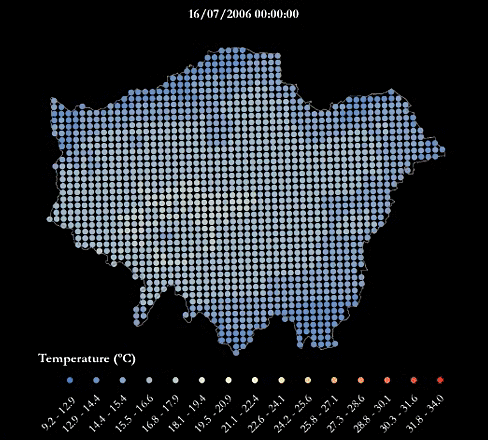
London’s Urban Heat Island - During A Warm Summer
- data.europa.eu
pdf, zip+ more versionsShareFacebookTwitterEmailClick to copy linkLink copiedCiteGreater London Authority, London’s Urban Heat Island - During A Warm Summer [Dataset]. https://data.europa.eu/data/datasets/londons-urban-heat-island-during-a-warm-summer?locale=lvpdf, zipAvailable download formatsDataset authored and provided byGreater London AuthorityArea coveredLondonDescriptionFor an urban heat island map during an average summer see this dataset.
A heatwave refers to a prolonged period of unusually hot weather. While there is no standard definition of a heatwave in England, the Met Office uses the World Meteorological Organization definition of a heatwave, which is "when the daily maximum temperature of more than five consecutive days exceeds the average maximum temperature by 5°C, the normal period being 1961-1990". They are common in the northern and southern hemisphere during summer have historically been associated with health problems and an increase in mortality.
The urban heat island (UHI) is the phenomenon where temperatures are relatively higher in cities compared to surrounding rural areas due to, for example, the urban surfaces and anthropogenic heat sources.
This urban heat island map was produced using LondUM, a specific set-up of the Met Office Unified Model version 6.1 for London. It uses the Met Office Reading Surface Exchange Scheme (MORUSES), as well as urban morphology data derived from Virtual London. The model was run from May until September 2006 and December 2006. This map shows average surface temperatures over the summer period of 2006 at a 1km by 1km resolution. To find out more about LondUM, see the University of Reading’s website.
The hourly outputs from LondUM have been aggregated and mapped by Jonathon Taylor, UCL Institute for Environmental Design and Engineering. Variables include:
- WSAVGMAX= the average of the maximum daily temperatures across the summer period (May 26th-August 31st)
- WSAVG=the average temperature across the summer period
- WSAVGMIN = the average minimum daily temperature across the summer period
- HWAVGMAX= the average of the maximum daily temperatures across the 2006 heatwave (July 16th-19th)
- HWAVG=the average temperature across the across the 2006 heatwave
- HWAVGMIN = the average minimum daily temperature across 2006 heatwave period
The maps are also available as one combined PDF.
The gif below maps the temperatures across London during the four-day period of 16-19th July, which was considered a heatwave.
If you make use of the LondUM data, please use the following citation to acknowledge the data and reference the publication below for model description:
LondUM (2011). Model data generated by Sylvia I. Bohnenstengel (*), Department of Meteorology, University of Reading and data retrieved from http://www.met.reading.ac.uk/~sws07sib/home/LondUM.html.
(*) Now at Metoffice@Reading, Email: sylvia.bohnenstengel@metoffice.gov.uk
Bohnenstengel SI, Evans S, Clark P and Belcher SeE (2011) Simulations of the London Urban Heat island. Quarterly journal of the Royal Meteorological Society, 137(659). pp. 1625-1640. ISSN 1477-870X doi 10.1002/qj.855. LondUM data (2013).
Regional climate values for the Mean Temperature - Dataset - data.gov.uk
- ckan.publishing.service.gov.uk
Updated Feb 24, 2011+ more versionsShareFacebookTwitterEmailClick to copy linkLink copiedCiteckan.publishing.service.gov.uk (2011). Regional climate values for the Mean Temperature - Dataset - data.gov.uk [Dataset]. https://ckan.publishing.service.gov.uk/dataset/regional-climate-values-for-mean-temperatureDataset updatedFeb 24, 2011LicenseOpen Government Licence 3.0http://www.nationalarchives.gov.uk/doc/open-government-licence/version/3/
License information was derived automaticallyDescriptionRegional climate values for an element, ordered by year -Minimum Tempature. Allowances have been made for topographic, coastal and urban effects where relationships are found to exist. Seasons: Winter=Dec-Feb, Spring=Mar-May, Summer=June-Aug, Autumn=Sept-Nov. (Winter: Year refers to Jan/Feb).
- n
MIDAS Open: UK hourly weather observation data, v202407
- data-search.nerc.ac.uk
Updated Jul 18, 2021ShareFacebookTwitterEmailClick to copy linkLink copiedCite(2021). MIDAS Open: UK hourly weather observation data, v202007 [Dataset]. https://data-search.nerc.ac.uk/geonetwork/srv/search?keyword=hourlyDataset updatedJul 18, 2021Area coveredUnited KingdomDescriptionThe UK hourly weather observation data contain meteorological values measured on an hourly time scale. The measurements of the concrete state, wind speed and direction, cloud type and amount, visibility, and temperature were recorded by observation stations operated by the Met Office across the UK and transmitted within SYNOP, DLY3208, AWSHRLY and NCM messages. The sunshine duration measurements were transmitted in the HSUN3445 message. The data spans from 1875 to 2023. This version supersedes the previous version of this dataset and a change log is available in the archive, and in the linked documentation for this record, detailing the differences between this version and the previous version. The change logs detail new, replaced and removed data. These include the addition of data for calendar year 2023. For details on observing practice see the message type information in the MIDAS User Guide linked from this record and relevant sections for parameter types. This dataset is part of the Midas-open dataset collection made available by the Met Office under the UK Open Government Licence, containing only UK mainland land surface observations owned or operated by Met Office. It is a subset of the fuller, restricted Met Office Integrated Data Archive System (MIDAS) Land and Marine Surface Stations dataset, also available through the Centre for Environmental Data Analysis - see the related dataset section on this record. Note, METAR message types are not included in the Open version of this dataset. Those data may be accessed via the full MIDAS hourly weather data.
Long-term climatic data for cities in Asia
- kaggle.com
zipUpdated Mar 18, 2024ShareFacebookTwitterEmailClick to copy linkLink copiedCiteRahdan. M. ArioB (2024). Long-term climatic data for cities in Asia [Dataset]. https://www.kaggle.com/datasets/mohammadrahdanmofrad/long-term-climatic-data-for-cities-in-asiazip(38203945 bytes)Available download formatsDataset updatedMar 18, 2024AuthorsRahdan. M. ArioBLicenseAttribution-ShareAlike 4.0 (CC BY-SA 4.0)https://creativecommons.org/licenses/by-sa/4.0/
License information was derived automaticallyArea coveredAsiaDescriptionDatasets provides long-term climate data for large Asian cities with populations over 500,000. The dataset includes data on cloud cover, temperature range, number of frost days, potential evapotranspiration, precipitation, minimum temperature, mean temperature, maximum temperature, relative humidity, and number of wet days. The dataset includes data for 831 cities.
Columns:
- ID
- Date
- Latitude
- Longitude
- cld: Cloud cover (%)
- dtr: Temperature range (°C)
- frs: Number of frost days
- pet: Potential evapotranspiration (mm)
- pre: Precipitation (mm)
- tmn: Minimum temperature (°C)
- tmp: Mean temperature (°C)
- tmx: Maximum temperature (°C)
- vap: Relative humidity (%)
- wet: Number of wet days
Inspiration:
Are you interested in predicting the future weather conditions in your city or one of the 831 cities in our climate dataset? Our climate dataset contains data on various climate metrics, including temperature, precipitation, cloud cover, wind speed, and humidity. This data can be used to train a machine learning model that can predict future weather conditions with high accuracy. Imagine using a machine learning model to predict the weather in your city for the next week, month, or year. This information could be used to make decisions about planning, adaptation, and risk mitigation.Please note:
This dataset contains satellite-derived climate data from the website https://crudata.uea.ac.uk. Satellite data are measured using sensors that may be subject to error. Therefore, it is possible that these data may differ from ground-based observations, which are typically used to generate real-world data. This difference is generally greater in remote areas and regions with high cloud.- w
Energy Trends and Prices statistical release: 26 May 2016
- gov.uk
Updated May 26, 2016+ more versionsShareFacebookTwitterEmailClick to copy linkLink copiedCiteDepartment of Energy & Climate Change (2016). Energy Trends and Prices statistical release: 26 May 2016 [Dataset]. https://www.gov.uk/government/statistics/energy-trends-and-prices-statistical-release-26-may-2016Dataset updatedMay 26, 2016Dataset provided byGOV.UKAuthorsDepartment of Energy & Climate ChangeDescriptionEnergy production and consumption statistics are provided in total and by fuel, and provide an analysis of the latest 3 months data compared to the same period a year earlier. Energy price statistics cover domestic price indices, prices of road fuels and petroleum products and comparisons of international road fuel prices.
Energy production and consumption
Highlights for the 3 month period January to March 2016, compared to the same period a year earlier include:
- Primary energy consumption in the UK on a fuel input basis fell by 4.6%, on a temperature adjusted basis consumption fell by 2.9% continuing the downward trend. (table ET 1.2)
- Indigenous energy production rose by 3.9%, boosted by increased UK Continental Shelf production. (table ET 1.1)
- Electricity generation by Major Power Producers down 4.0%, with coal down 50% but offset by increase in gas up 54%.* (table ET 5.4)
- Gas provided 40.4% of electricity generation by Major Power Producers, with renewables at 21.0%, nuclear at 20.5% and coal at a record low of 18.0%.* (table ET 5.4)
- In March 2016 coal imports were at a record low level, despite production also being at record low levels, reflecting reduced demand from electricity generators. (table ET 2.5)
- Wind generation by Major Power Producers down 3.8%, with offshore up 10.0% due to increased capacity, but onshore down 16.4% due to lower average wind speeds.* (table ET 5.4)
- Low carbon share of electricity generation by Major Power Producers up 1.7 percentage points to 41.5%, due to rises in renewables, particularly bioenergy, generation.* (table ET 5.4)
*Major Power Producers (MPPs) data published monthly, all generating companies data published quarterly.
Energy prices
Highlights for May 2016 compared to April 2016:
- Petrol prices up 2.1 pence per litre on month whilst diesel prices up 2.4 pence per litre, these rises reflect the increase in the price of crude oil. (table QEP 4.1.1)
Contacts
Lead statistician Iain Macleay, Tel 0300 068 5048
Press enquiries, Tel 0300 060 4000
Data periods
Statistics on monthly production and consumption of coal, electricity, gas, oil and total energy include data for the UK for the period up to the end of March 2016.
Statistics on average temperatures, wind speeds, sun hours and rainfall include data for the UK for the period up to the end of April 2016.
Statistics on energy prices include retail price data for the UK for April 2016, and petrol & diesel data for May 2016, with EU comparative data for April 2016.
Next release
The next release of provisional monthly energy statistics will take place on 30 June 2016.
Data tables
To access the data tables associated with this release please click on the relevant subject link(s) below. For further information please use the contact details provided.
Please note that the links below will always direct you to the latest data tables. If you are interested in historical data tables please contact DECC (kevin.harris@decc.gsi.gov.uk)
Subject and table number Energy production and consumption, and weather data Total Energy Contact: Kevin Harris, Tel: 0300 068 5041 ET 1.1 Indigenous production of primary fuels ET 1.2 Inla - D
Data from: Adverse weather conditions for UK wheat production under climate...
- ckan.grassroots.tools
api, pdf, xmlUpdated Sep 15, 2022ShareFacebookTwitterEmailClick to copy linkLink copiedCiteRothamsted Research (2022). Adverse weather conditions for UK wheat production under climate change [Dataset]. https://ckan.grassroots.tools/dataset/90a882d6-ff8f-4848-b9d3-34d71b7fec98pdf, api, xmlAvailable download formatsDataset updatedSep 15, 2022Dataset provided byRothamsted ResearchLicensehttps://www.elsevier.com/tdm/userlicense/1.0/https://www.elsevier.com/tdm/userlicense/1.0/
Area coveredUnited KingdomDescriptionWinter wheat is an important crop in the UK, suited to the typical weather conditions in the current climate. In a changing climate the increased frequency and severity of adverse weather events, which are often localised, are considered a major threat to wheat production. In the present study we assessed a range of adverse weather conditions, which can significantly affect yield, under current and future climates based on adverse weather indices. We analysed changes in the frequency, magnitude and spatial patterns of 10 adverse weather indices, at 25 sites across the UK, using climate scenarios from the CMIP5 ensemble of global climate models (GCMs) and two greenhouse gas emissions (RCP4.5 and RCP8.5). The future UK climate is expected to remain favourable for wheat production, with most adverse weather indicators reducing in magnitude by the mid-21st century. Hotter and drier summers would improve sowing and harvesting conditions and reduce the risk of lodging. The probability of late frosts and heat stress during reproductive and grain filling periods would likely remain small in 2050. Wetter winter and spring could cause issues with waterlogging. The severity of drought stress during reproduction would generally be lower in 2050, however localised differences suggest it is important to examine drought at a small spatial scale. Prolonged water stress does not increase considerably in the UK, as may be expected in other parts of Europe. Climate projections based on the CMIP5 ensemble reveal considerable uncertainty in the magnitude of adverse weather conditions including waterlogging, drought and water stress. The variation in adverse weather conditions due to GCMs was generally greater than between emissions scenarios. Accordingly, CMIP5 ensembles should be used in the assessment of adverse weather conditions for crop production to indicate the full range of possible impacts, which a limited number of GCMs may not provide.
- n
MIDAS Open: UK hourly weather observation data, v202007
- data-search.nerc.ac.uk
- catalogue.ceda.ac.uk
Updated Jul 18, 2021ShareFacebookTwitterEmailClick to copy linkLink copiedCite(2021). MIDAS Open: UK hourly weather observation data, v202007 [Dataset]. https://data-search.nerc.ac.uk/geonetwork/srv/search?keyword=hourlyDataset updatedJul 18, 2021Area coveredUnited KingdomDescriptionThe UK hourly weather observation data contain meteorological values measured on an hourly time scale. The measurements of the concrete state, wind speed and direction, cloud type and amount, visibility, and temperature were recorded by observation stations operated by the Met Office across the UK and transmitted within SYNOP, DLY3208, AWSHRLY and NCM messages. The sunshine duration measurements were transmitted in the HSUN3445 message. The data spans from 1875 to 2019. This version supersedes the previous version of this dataset and a change log is available in the archive, and in the linked documentation for this record, detailing the differences between this version and the previous version. The change logs detail new, replaced and removed data. Of particular note, however, is that as well as including data for 2019, historical data recovery has added temperature and weather data for Bude (1937-1958), Teignmouth (1912-1930), and Eskdalemuir (1915-1948). For details on observing practice see the message type information in the MIDAS User Guide linked from this record and relevant sections for parameter types. This dataset is part of the Midas-open dataset collection made available by the Met Office under the UK Open Government Licence, containing only UK mainland land surface observations owned or operated by Met Office. It is a subset of the fuller, restricted Met Office Integrated Data Archive System (MIDAS) Land and Marine Surface Stations dataset, also available through the Centre for Environmental Data Analysis - see the related dataset section on this record. Note, METAR message types are not included in the Open version of this dataset. Those data may be accessed via the full MIDAS hourly weather data.
- i
Atlantic - European North West Shelf Subsurface temperature anomaly
- sextant.ifremer.fr
+ more versionsShareFacebookTwitterEmailClick to copy linkLink copiedCiteNWS-METOFFICE-EXETER-UK, Atlantic - European North West Shelf Subsurface temperature anomaly [Dataset]. https://sextant.ifremer.fr/record/9fa4d0fc-7bc4-436a-a6ba-834d482c1c16/Dataset provided byNWS-METOFFICE-EXETER-UK
MOI-OMI-SERVICELicenseMIT Licensehttps://opensource.org/licenses/MIT
License information was derived automaticallyTime period coveredJan 1, 1901Area coveredDescription'''DEFINITION''' The subsurface temperature anomaly has been derived from the regional reanalysis of the CMEMS NWS MFC group for the North-West European Shelf Seas (product reference NWSHELF_MULTIYEAR_PHY_004_009). Horizontal averaging has been conducted over just the shelf, defined as the contiguous region surrounding the UK where sea depth is no more than 200m. The profiles of the annual mean temperature anomaly have been calculated relative to the reference period of 1993-2019. The time series shows monthly anomalies calculated from monthly means. CMEMS Ocean State Report (Mulet et al., 2018) gives the broader context for these anomalies.
'''CONTEXT''' The North-West European Shelf Seas are the waters on the continental shelf adjoining the North-East Atlantic. Geographically, they can be divided into 5 regions: the North Sea, the English Channel, the Celtic Sea, the Irish Sea, and the North-Western Approaches. The temperatures in these seas is moderated by inflow from the North Atlantic Drift (a continuation of the Gulf Stream), into the Irish Sea and English Channel from the south-west and into the North Sea from the north and north-west. In Winter, this Atlantic water maintains surface temperatures no colder than 10°C in western regions. Cooler temperatures, below 3°C, can occur in eastern parts near continental coasts. In Summer, those eastern coastal regions can warm to as much as 18°C, especially in the shallow waters of the southern North Sea. Stratification occurs in the Summer months, starting around May in the northern part of the domain, and then extending southwards (Paramor et al., 2009). Currents are dominated by the strong semi-diurnal tides which act to mix the water and reduce stratification. This is especially noticeable in the shallow southern North Sea.
'''CMEMS KEY FINDINGS''' Interannual variations of the subsurface temperature anomaly averaged across the domain range from -1°C to +1°C within the upper 100-m deep layer over the period 1993-2019. There is some long-term variability, with warm anomalies for most of the first decade of the 21st century. This is a decade in which 6 of the 10 warmest years on record occurred for air temperature over the UK (Kendon et al., 2019). The 4 other warmest years for UK climate were 2011, 2014, 2017 and 2018. 2011 and 2017 correspond to warm anomalies through the depth of the Shelf. 2018 saw an unusually hot Summer heatwave for the atmosphere, which is reflected in a short-lived and shallow warm anomaly (to 25m depth) in the reanalysis. 2014 was for UK climate the hottest year on record. This corresponds to a stronger and longer-lived anomaly in the reanalysis, but only down to around 75m depth. Temperatures in deeper layers may be moderated by inflow to the region from the North Atlantic drift. 2019 was overall slightly warmer than average in near-surface layers, and slightly cooler below 100m depth.
Monthly maximum temperature in England 2015-2025
- statista.com
Updated Jan 15, 2015ShareFacebookTwitterEmailClick to copy linkLink copiedCiteStatista (2015). Monthly maximum temperature in England 2015-2025 [Dataset]. https://www.statista.com/statistics/584991/monthly-maximum-temperature-in-england/Dataset updatedJan 15, 2015Time period coveredJan 2015 - Sep 2025Area coveredEnglandDescriptionSince January 2015, the highest maximum monthly temperature in England was measured in July 2018, at 24.8 degrees Celsius. July temperatures declined in the following years, and measured 22.9 degrees Celsius in 2025. Further information about the weather in the United Kingdom can be found here.
- e
Mortality Risk from High Temperatures in London (Triple Jeopardy Mapping)
- data.europa.eu
pdf, zip+ more versionsShareFacebookTwitterEmailClick to copy linkLink copiedCiteGreater London Authority, Mortality Risk from High Temperatures in London (Triple Jeopardy Mapping) [Dataset]. https://data.europa.eu/data/datasets/mortality-risk-from-high-temperatures-in-london-triple-jeopardy-mapping?locale=nozip, pdfAvailable download formatsDataset authored and provided byGreater London AuthorityArea coveredLondonDescriptionA heatwave refers to a prolonged period of unusually hot weather. While there is no standard definition of a heatwave in England, the Met Office generally uses the World Meteorological Organization definition of a heatwave, which is "when the daily maximum temperature of more than five consecutive days exceeds the average maximum temperature by 5°C, the normal period being 1961-1990". They are common in the northern and southern hemisphere during summer, and have historically been associated with health problems and an increase in mortality.
The urban heat island (UHI) is the phenomenon where temperatures are relatively higher in cities compared to surrounding rural areas due to, for example, the urban surfaces and anthropogenic heat sources. For an example of an urban heat island map during an average summer, see this dataset. For an example of an urban heat island map during a warm summer, see this dataset.
As well as outdoor temperature, an individual’s heat exposure may also depend on the type of building they are inside, if indoors. Indoor temperature exposure may depend on a number of characteristics, such as the building geometry, construction materials, window sizes, and the ability to add extra ventilation. It is also known that people have different vulnerabilities to heat, with some more prone to negative health issues when exposed to high temperatures.
This Triple Jeopardy dataset combines:
- Urban Heat Island information for London, based on the 55 days between May 26th -July 19th 2006, where the last four days were considered a heatwave
- An estimate of the indoor temperatures for individual dwellings in London across this time period
- Population age, as a proxy for heat vulnerability, and distribution
From this, local levels of heat-related mortality were estimated using a mortality model derived from epidemiological data.
The dataset comprises four layers:
- Ind_Temp_A – indoor Temperature Anomaly is the difference in degrees Celsius between the estimated indoor temperatures for dwellings and the average indoor temperature estimate for the whole of London, averaged by ward. Positive numbers show dwellings with a greater tendency to overheat in comparison with the London average
- HeatMortpM – total estimated mortality due to heat (outdoor and indoor) per million population over the entire 55 day period, inclusive of age effects
- HeatMorUHI – estimated mortality per million population due to increased outdoor temperature exposure caused by the UHI over the 55 day period (excluding the effect of overheating housing), inclusive of age effects
- HeatMorInd - estimated mortality per million population due to increased temperature exposure caused by heat-vulnerable dwellings (excluding the effect of the UHI) over the 55 day period, inclusive of age effects More information is on this website and in the Triple Jeopardy leaflet.
The maps are also available as one combined PDF. More information is on this website and in the Triple Jeopardy leaflet.
 FacebookTwitter
Monthly average daily temperatures in the United Kingdom 2015-2024
The highest average temperature recorded in 2024 until November was in August, at 16.8 degrees Celsius. Since 2015, the highest average daily temperature in the UK was registered in July 2018, at 18.7 degrees Celsius. The summer of 2018 was the joint hottest since institutions began recording temperatures in 1910. One noticeable anomaly during this period was in December 2015, when the average daily temperature reached 9.5 degrees Celsius. This month also experienced the highest monthly rainfall in the UK since before 2014, with England, Wales, and Scotland suffering widespread flooding. Daily hours of sunshine Unsurprisingly, the heat wave that spread across the British Isles in 2018 was the result of particularly sunny weather. July 2018 saw an average of 8.7 daily sun hours in the United Kingdom. This was more hours of sun than was recorded in July 2024, which only saw 5.8 hours of sun. Temperatures are on the rise Since the 1960s, there has been an increase in regional temperatures across the UK. Between 1961 and 1990, temperatures in England averaged nine degrees Celsius, and from 2013 to 2022, average temperatures in the country had increased to 10.3 degrees Celsius. Due to its relatively southern location, England continues to rank as the warmest country in the UK.