Mapping Priority Index
- geodata.myfwc.com
- geodata.floridagio.gov
Updated Jan 1, 2020+ more versions Share
Share Facebook
 Twitter
 EmailClick to copy linkLink copiedCiteFlorida Fish and Wildlife Conservation Commission (2020). Mapping Priority Index [Dataset]. https://geodata.myfwc.com/datasets/mapping-priority-indexDataset updatedJan 1, 2020Area coveredDescription
This GIS data represents the input solicited from the science and management community on coastal and sea-floor mapping priorities. Representatives from multiple federal, state, academic, and private entities provided input on priorities for high-resolution seafloor data relative to their constituent science and management mapping needs.In order to address the significant gaps in modern seafloor data, Florida Coastal Mapping Program (FCMaP) undertook a formal prioritization process to solicit input from stakeholders to prioritize coastal and seafloor mapping needs. Stakeholder input was collected using an online mapping tool. Florida coastal water areas were gridded into ten square kilometer cells following the US National Grid out to 200 meter depth. Stakeholders populated the grid cells at a regional level (6 regions across the state) with an allocated number of coins to indicate their highest priority mapping needs. Along with the spatial distribution of areas of interest, stakeholders were also asked to indicate why they need the data and what ancillary data they require for their mapping application.
- a
Prioritization 2: Deep-water Mapping (20 to 200m)
- florida-coastal-mapping-program-fio-maps.hub.arcgis.com
Updated Jun 26, 2023ShareFacebookTwitterEmailClick to copy linkLink copiedCiteFlorida Institute of Oceanography (2023). Prioritization 2: Deep-water Mapping (20 to 200m) [Dataset]. https://florida-coastal-mapping-program-fio-maps.hub.arcgis.com/datasets/prioritization-2-deep-water-mapping-20-to-200mDataset updatedJun 26, 2023Dataset authored and provided byFlorida Institute of OceanographyDescriptionThis 2023 study is a continuation of 2019 prioritization study done by FCMaP in which two depth ranges were assessed: nearshore (0 to 20 m depth) and shelf (20 to 200m depth). The State of Florida has since been awarded $100 million in general revenue funds to capture statewide bathymetric lidar. The Florida Seafloor Mapping Initiative (FSMI) is designed with a focus on nearshore (0 to 20m depth) areas and mapping will begin later this summer/fall of 2023. During the FCMaP 2022 Annual Summit the community determined a further analysis of the deeper water areas (20 to 200m) and resulting products should be conducted as stakeholder needs for surveys and products may have shifted in response to storms, planned use and funding. In response to this action item the FCMaP Prioritization 2: Deep-water study was conducted to: 1) determine the implementation of systematic mapping of deeper waters around Florida and 2) understand the full scope of the community’s need for deep-water data.The FCMaP worked in conjunction with NOAA's Integrated Ocean and Coastal Mapping (IOCM) Program to conduct the new spatial prioritization exercise. On June 20, 2023 FCMaP and IOCM held a virtual webinar to review 2019 prioritization efforts, discuss current mapping efforts, and provide instructions on how to use the prioritization tool (FCMaP Prioritization 2: Deep-water (20-200m) Prioritization Tool - Background and Guidance for Participating ). Accounts were created for stakeholders to access the online platform to participate in the prioritization. It was requested that FCMaP be provided one representative (POC) from each agency, lab, group etc. to participate on behalf of their organization.
- a
FcMAP PrioritiesIndexMap StoryMapEmbed
- noaa.hub.arcgis.com
Updated May 10, 2023ShareFacebookTwitterEmailClick to copy linkLink copiedCiteNOAA GeoPlatform (2023). FcMAP PrioritiesIndexMap StoryMapEmbed [Dataset]. https://noaa.hub.arcgis.com/maps/0a657e18073941c29ea25baf9b1a3fe1Dataset updatedMay 10, 2023Dataset authored and provided byNOAA GeoPlatformArea coveredDescriptionFcMAP 2022 Priorities Study Results Webmap for use in 2DEEP: Florida Deepwater Prioritization Exercisehttps://storymaps.arcgis.com/stories/16dfc1d501864610904e34c4244e92dfhttps://noaa.maps.arcgis.com/home/item.html?id=16dfc1d501864610904e34c4244e92df
- N
liujinbnu's temporary collection: L Hipp FCmap
- neurovault.org
niftiUpdated Nov 9, 2020+ more versionsShareFacebookTwitterEmailClick to copy linkLink copiedCite(2020). liujinbnu's temporary collection: L Hipp FCmap [Dataset]. http://identifiers.org/neurovault.image:427612niftiAvailable download formatsUnique identifierhttps://identifiers.org/neurovault.image:427612Dataset updatedNov 9, 2020LicenseCC0 1.0 Universal Public Domain Dedicationhttps://creativecommons.org/publicdomain/zero/1.0/
License information was derived automaticallyDescription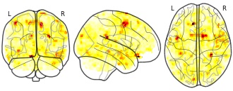
Collection description
None
Subject species
homo sapiens
Modality
fMRI-BOLD
Cognitive paradigm (task)
rest eyes closed
Map type
F
- p
Blood volume control FC map
- discover.pennsieve.io
Updated Oct 10, 2025ShareFacebookTwitterEmailClick to copy linkLink copiedCiteDavid Nickerson; David Brooks; Shelley Fong; Peter Hunter; David Nickerson; David Brooks; Shelley Fong; Peter Hunter (2025). Blood volume control FC map [Dataset]. http://doi.org/10.26275/mf4h-kzbsUnique identifierhttps://doi.org/10.26275/mf4h-kzbsDataset updatedOct 10, 2025Dataset provided bySPARCAuthorsDavid Nickerson; David Brooks; Shelley Fong; Peter Hunter; David Nickerson; David Brooks; Shelley Fong; Peter HunterLicenseAttribution 4.0 (CC BY 4.0)https://creativecommons.org/licenses/by/4.0/
License information was derived automaticallyDescriptionThis dataset captures a simple blood volume control FC map, consisting of the mathematical model, simulation protocols, and visual maps for use on the SPARC Portal.
- a
FCMaP2 Deep-waterPriorities WidgetBasemap
- noaa.hub.arcgis.com
Updated Jun 15, 2023ShareFacebookTwitterEmailClick to copy linkLink copiedCiteNOAA GeoPlatform (2023). FCMaP2 Deep-waterPriorities WidgetBasemap [Dataset]. https://noaa.hub.arcgis.com/maps/737888ea7dca4b819aa3be20fd47e42dDataset updatedJun 15, 2023Dataset authored and provided byNOAA GeoPlatformArea coveredDescriptionFCMaP Prioritization 2: Deepwater (20-200m) Priorities Study- basemap for priorities collection web-app. Includes reference layers: Depth bands 20-200m from Florida Fish & Wildlife Conservation Commission REST, previous prioritization results from FCMaP (re-referenced to IOCM 3DEP grid), and updated FCMaP Seafloor Mapping Inventory Gap Analysis.
- f
FSMI Regions of Interest
- floridagio.gov
- geodata.floridagio.gov
- +1more
Updated Dec 1, 2022+ more versionsShareFacebookTwitterEmailClick to copy linkLink copiedCiteState of Florida Geographic Information Office (2022). FSMI Regions of Interest [Dataset]. https://www.floridagio.gov/datasets/FGIO::fsmi-regions-of-interestDataset updatedDec 1, 2022Dataset authored and provided byState of Florida Geographic Information OfficeArea coveredDescriptionLandward boundary limit for topo-bathymetric lidar acquisition of the Florida Seafloor Mapping Initiative (FSMI). Includes most Estuaries, Aquatic Preserves (AP), and National Estuaries Research Reserves (NERR) in the state. The distance for the landward limit is between 500 m to 1,000 m from the shoreline, except in areas that were identified as high-priority by the Florida Coastal Mapping Program (FCMaP) in their Priority Workshops conducted between 2018 and 2019, and areas identified as high-interest by DEP’s Office of Resilience and Coastal Protection (ORCP) AP and NERR managers. Some of these identified areas can extend beyond to 2,000 m landward.Polygons of submerged areas created from a combination of the National Hydrography Dataset, and estuarine zones from the National Fish Habitat Action Plan (NFHAP). These water areas are for general estimation of coverage, only, and may not perfectly align with on-the-ground (water) coverage.
- N
guoxiaonan's temporary collection: insula FC map
- neurovault.org
niftiUpdated Dec 30, 2016+ more versionsShareFacebookTwitterEmailClick to copy linkLink copiedCite(2016). guoxiaonan's temporary collection: insula FC map [Dataset]. http://identifiers.org/neurovault.image:39744niftiAvailable download formatsUnique identifierhttps://identifiers.org/neurovault.image:39744Dataset updatedDec 30, 2016LicenseCC0 1.0 Universal Public Domain Dedicationhttps://creativecommons.org/publicdomain/zero/1.0/
License information was derived automaticallyDescription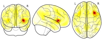
Collection description
None
Subject species
homo sapiens
Modality
fMRI-BOLD
Cognitive paradigm (task)
rest eyes closed
Map type
T
- a
June News & Updates: Florida Coastal Mapping Program
- florida-coastal-mapping-program-fio-maps.hub.arcgis.com
Updated May 19, 2025ShareFacebookTwitterEmailClick to copy linkLink copiedCiteFlorida Institute of Oceanography (2025). June News & Updates: Florida Coastal Mapping Program [Dataset]. https://florida-coastal-mapping-program-fio-maps.hub.arcgis.com/datasets/june-news-updates-florida-coastal-mapping-programDataset updatedMay 19, 2025Dataset authored and provided byFlorida Institute of OceanographyArea coveredFloridaDescriptionThe hybrid event was held March 12-13, 2025 at the University of South Florida, Student Life Center in Saint Petersburg, FL. The Summit accommodated virtual participants via Teams which allowed full in-person and virtual participation during Q&A as well as full discussion sessions. The purpose of the annual summit is to bring together stakeholders, to discuss recent mapping activities, future plans and strategies to achieve a mapped Florida seafloor.The focus of this year's event was the Florida Seafloor Mapping Initiative (FSMI) progress on the collection of coastal topobathymetric lidar and sonar data which laid the groundwork for discussions on advancing the engagement and data awareness portion of the FCMaP strategic plan in order to help lead in the effort to build a more structured Community of Practice (CoP).
- a
2DEEP WidgetReference WebMap
- noaa.hub.arcgis.com
Updated Jun 12, 2023ShareFacebookTwitterEmailClick to copy linkLink copiedCiteNOAA GeoPlatform (2023). 2DEEP WidgetReference WebMap [Dataset]. https://noaa.hub.arcgis.com/maps/9f9a3d2d1c57423a9079d79b1496c20bDataset updatedJun 12, 2023Dataset authored and provided byNOAA GeoPlatformArea coveredDescriptionFcMAP 2023 Deepwater Prioritization Widget: instructional webmap for use in Florida Deepwater Prioritization Exercise. Web-map is referenced to provide context for widget use in a map-tour setting with step-by-step instructions for participants to submit priorities. https://storymaps.arcgis.com/stories/16dfc1d501864610904e34c4244e92dfhttps://noaa.maps.arcgis.com/home/item.html?id=16dfc1d501864610904e34c4244e92df
- N
mlopezsola's temporary collection: marina fc map
- neurovault.org
niftiUpdated Mar 11, 2016+ more versionsShareFacebookTwitterEmailClick to copy linkLink copiedCite(2016). mlopezsola's temporary collection: marina fc map [Dataset]. http://identifiers.org/neurovault.image:17301niftiAvailable download formatsUnique identifierhttps://identifiers.org/neurovault.image:17301Dataset updatedMar 11, 2016LicenseCC0 1.0 Universal Public Domain Dedicationhttps://creativecommons.org/publicdomain/zero/1.0/
License information was derived automaticallyDescription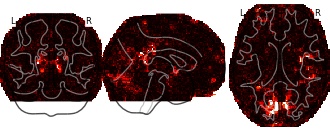
Collection description
None
Subject species
homo sapiens
Modality
fMRI-BOLD
Cognitive paradigm (task)
pain monitor/discrimination task
Map type
P

Not seeing a result you expected?
Learn how you can add new datasets to our index.
FacebookTwitterThis GIS data represents the input solicited from the science and management community on coastal and sea-floor mapping priorities. Representatives from multiple federal, state, academic, and private entities provided input on priorities for high-resolution seafloor data relative to their constituent science and management mapping needs.In order to address the significant gaps in modern seafloor data, Florida Coastal Mapping Program (FCMaP) undertook a formal prioritization process to solicit input from stakeholders to prioritize coastal and seafloor mapping needs. Stakeholder input was collected using an online mapping tool. Florida coastal water areas were gridded into ten square kilometer cells following the US National Grid out to 200 meter depth. Stakeholders populated the grid cells at a regional level (6 regions across the state) with an allocated number of coins to indicate their highest priority mapping needs. Along with the spatial distribution of areas of interest, stakeholders were also asked to indicate why they need the data and what ancillary data they require for their mapping application.