Annual Count of Hot Summer Days - Projections (12km)
- climatedataportal.metoffice.gov.uk
- hub.arcgis.com
Updated Feb 7, 2023+ more versions Share
Share Facebook
 Twitter
 EmailClick to copy linkLink copiedCiteMet Office (2023). Annual Count of Hot Summer Days - Projections (12km) [Dataset]. https://climatedataportal.metoffice.gov.uk/datasets/annual-count-of-hot-summer-days-projections-12kmDataset updatedFeb 7, 2023Area coveredDescription
[Updated 28/01/25 to fix an issue in the ‘Lower’ values, which were not fully representing the range of uncertainty. ‘Median’ and ‘Higher’ values remain unchanged. The size of the change varies by grid cell and fixed period/global warming levels but the average difference between the 'lower' values before and after this update is 0.2.]What does the data show? The Annual Count of Hot Summer Days is the number of days per year where the maximum daily temperature is above 30°C. It measures how many times the threshold is exceeded (not by how much) in a year. Note, the term ‘hot summer days’ is used to refer to the threshold and temperatures above 30°C outside the summer months also contribute to the annual count. The results should be interpreted as an approximation of the projected number of days when the threshold is exceeded as there will be many factors such as natural variability and local scale processes that the climate model is unable to represent.The Annual Count of Hot Summer Days is calculated for two baseline (historical) periods 1981-2000 (corresponding to 0.51°C warming) and 2001-2020 (corresponding to 0.87°C warming) and for global warming levels of 1.5°C, 2.0°C, 2.5°C, 3.0°C, 4.0°C above the pre-industrial (1850-1900) period. This enables users to compare the future number of hot summer days to previous values.What are the possible societal impacts?The Annual Count of Hot Summer Days indicates increased health risks, transport disruption and damage to infrastructure from high temperatures. It is based on exceeding a maximum daily temperature of 30°C. Impacts include:Increased heat related illnesses, hospital admissions or death.Transport disruption due to overheating of railway infrastructure. Overhead power lines also become less efficient. Other metrics such as the Annual Count of Summer Days (days above 25°C), Annual Count of Extreme Summer Days (days above 35°C) and the Annual Count of Tropical Nights (where the minimum temperature does not fall below 20°C) also indicate impacts from high temperatures, however they use different temperature thresholds.What is a global warming level?The Annual Count of Hot Summer Days is calculated from the UKCP18 regional climate projections using the high emissions scenario (RCP 8.5) where greenhouse gas emissions continue to grow. Instead of considering future climate change during specific time periods (e.g. decades) for this scenario, the dataset is calculated at various levels of global warming relative to the pre-industrial (1850-1900) period. The world has already warmed by around 1.1°C (between 1850–1900 and 2011–2020), whilst this dataset allows for the exploration of greater levels of warming. The global warming levels available in this dataset are 1.5°C, 2°C, 2.5°C, 3°C and 4°C. The data at each warming level was calculated using a 21 year period. These 21 year periods are calculated by taking 10 years either side of the first year at which the global warming level is reached. This time will be different for different model ensemble members. To calculate the value for the Annual Count of Hot Summer Days, an average is taken across the 21 year period. Therefore, the Annual Count of Hot Summer Days show the number of hot summer days that could occur each year, for each given level of warming. We cannot provide a precise likelihood for particular emission scenarios being followed in the real world future. However, we do note that RCP8.5 corresponds to emissions considerably above those expected with current international policy agreements. The results are also expressed for several global warming levels because we do not yet know which level will be reached in the real climate as it will depend on future greenhouse emission choices and the sensitivity of the climate system, which is uncertain. Estimates based on the assumption of current international agreements on greenhouse gas emissions suggest a median warming level in the region of 2.4-2.8°C, but it could either be higher or lower than this level.What are the naming conventions and how do I explore the data?This data contains a field for each global warming level and two baselines. They are named ‘HSD’ (where HSD means Hot Summer Days), the warming level or baseline, and ‘upper’ ‘median’ or ‘lower’ as per the description below. E.g. ‘Hot Summer Days 2.5 median’ is the median value for the 2.5°C warming level. Decimal points are included in field aliases but not field names e.g. ‘Hot Summer Days 2.5 median’ is ‘HotSummerDays_25_median’. To understand how to explore the data, see this page: https://storymaps.arcgis.com/stories/457e7a2bc73e40b089fac0e47c63a578Please note, if viewing in ArcGIS Map Viewer, the map will default to ‘HSD 2.0°C median’ values.What do the ‘median’, ‘upper’, and ‘lower’ values mean?Climate models are numerical representations of the climate system. To capture uncertainty in projections for the future, an ensemble, or group, of climate models are run. Each ensemble member has slightly different starting conditions or model set-ups. Considering all of the model outcomes gives users a range of plausible conditions which could occur in the future. For this dataset, the model projections consist of 12 separate ensemble members. To select which ensemble members to use, the Annual Count of Hot Summer Days was calculated for each ensemble member and they were then ranked in order from lowest to highest for each location. The ‘lower’ fields are the second lowest ranked ensemble member. The ‘upper’ fields are the second highest ranked ensemble member. The ‘median’ field is the central value of the ensemble.This gives a median value, and a spread of the ensemble members indicating the range of possible outcomes in the projections. This spread of outputs can be used to infer the uncertainty in the projections. The larger the difference between the lower and upper fields, the greater the uncertainty.‘Lower’, ‘median’ and ‘upper’ are also given for the baseline periods as these values also come from the model that was used to produce the projections. This allows a fair comparison between the model projections and recent past. Useful linksThis dataset was calculated following the methodology in the ‘Future Changes to high impact weather in the UK’ report and uses the same temperature thresholds as the 'State of the UK Climate' report.Further information on the UK Climate Projections (UKCP).Further information on understanding climate data within the Met Office Climate Data Portal.
Climate Change: Earth Surface Temperature Data
- kaggle.com
- redivis.com
zipUpdated May 1, 2017ShareFacebookTwitterEmailClick to copy linkLink copiedCiteBerkeley Earth (2017). Climate Change: Earth Surface Temperature Data [Dataset]. https://www.kaggle.com/datasets/berkeleyearth/climate-change-earth-surface-temperature-datazip(88843537 bytes)Available download formatsDataset updatedMay 1, 2017LicenseAttribution-NonCommercial-ShareAlike 4.0 (CC BY-NC-SA 4.0)https://creativecommons.org/licenses/by-nc-sa/4.0/
License information was derived automaticallyArea coveredEarthDescriptionSome say climate change is the biggest threat of our age while others say it’s a myth based on dodgy science. We are turning some of the data over to you so you can form your own view.

Even more than with other data sets that Kaggle has featured, there’s a huge amount of data cleaning and preparation that goes into putting together a long-time study of climate trends. Early data was collected by technicians using mercury thermometers, where any variation in the visit time impacted measurements. In the 1940s, the construction of airports caused many weather stations to be moved. In the 1980s, there was a move to electronic thermometers that are said to have a cooling bias.
Given this complexity, there are a range of organizations that collate climate trends data. The three most cited land and ocean temperature data sets are NOAA’s MLOST, NASA’s GISTEMP and the UK’s HadCrut.
We have repackaged the data from a newer compilation put together by the Berkeley Earth, which is affiliated with Lawrence Berkeley National Laboratory. The Berkeley Earth Surface Temperature Study combines 1.6 billion temperature reports from 16 pre-existing archives. It is nicely packaged and allows for slicing into interesting subsets (for example by country). They publish the source data and the code for the transformations they applied. They also use methods that allow weather observations from shorter time series to be included, meaning fewer observations need to be thrown away.
In this dataset, we have include several files:
Global Land and Ocean-and-Land Temperatures (GlobalTemperatures.csv):
- Date: starts in 1750 for average land temperature and 1850 for max and min land temperatures and global ocean and land temperatures
- LandAverageTemperature: global average land temperature in celsius
- LandAverageTemperatureUncertainty: the 95% confidence interval around the average
- LandMaxTemperature: global average maximum land temperature in celsius
- LandMaxTemperatureUncertainty: the 95% confidence interval around the maximum land temperature
- LandMinTemperature: global average minimum land temperature in celsius
- LandMinTemperatureUncertainty: the 95% confidence interval around the minimum land temperature
- LandAndOceanAverageTemperature: global average land and ocean temperature in celsius
- LandAndOceanAverageTemperatureUncertainty: the 95% confidence interval around the global average land and ocean temperature
Other files include:
- Global Average Land Temperature by Country (GlobalLandTemperaturesByCountry.csv)
- Global Average Land Temperature by State (GlobalLandTemperaturesByState.csv)
- Global Land Temperatures By Major City (GlobalLandTemperaturesByMajorCity.csv)
- Global Land Temperatures By City (GlobalLandTemperaturesByCity.csv)
The raw data comes from the Berkeley Earth data page.
Major Summer Heat Spots using Landsat-8 Thermal Satellite data - Dataset -...
- ckan.publishing.service.gov.uk
Updated Mar 26, 2021+ more versionsShareFacebookTwitterEmailClick to copy linkLink copiedCiteckan.publishing.service.gov.uk (2021). Major Summer Heat Spots using Landsat-8 Thermal Satellite data - Dataset - data.gov.uk [Dataset]. https://ckan.publishing.service.gov.uk/dataset/major-summer-heat-spots-using-landsat-8-thermal-satellite-dataDataset updatedMar 26, 2021DescriptionFine resolution satellite thermal data can be used as a basis for mapping the spatial distribution of urban surface temperatures and identifying urban hotspots. This dataset has been produced from satellite-derived land surface temperature (LST) data for the Greater London Area by ARTi Analytics BV as part of EXTREMA Global portfolio of services and reveals the city’s major daytime summertime hotspots. Outline methodology For spatial resolutions coarser than 30 m it can be reasonably assumed that the urban LST hotspots coincide with the urban air temperature hotspots1. Hence, thermal satellite data can be used so as to identify intra-urban areas with elevated temperatures. To generate a dataset that presents the LST spatial distribution and the corresponding hotspots for GLA, a five-year (2016-2020) time series of satellite-derived 100 m daytime LST images (in °C) is employed. The utilized data correspond only to summer months (i.e. June, July and August) so as to capture the hotspots with the most important impact on thermal discomfort, human health and energy demand, and are derived from Landsat-8 thermal infrared images. The next step after estimating the 2016-2020, average, summertime, daytime LST is to aggregate them to city block level. In addition to the average LST (avgLST), the avgLST standard deviation, minimum and maximum for each city block are also estimated. The aforementioned statistics are stored as new attributes in the Urban Atlas polygons and the updated vectors are then exported as a new shapefile. The spatial extent of this output shapefile corresponds to the boundaries of GLA.
MIDAS Open: UK daily temperature data, v202308
- catalogue.ceda.ac.uk
Updated Aug 7, 2024+ more versionsShareFacebookTwitterEmailClick to copy linkLink copiedCiteMet Office (2024). MIDAS Open: UK daily temperature data, v202308 [Dataset]. https://catalogue.ceda.ac.uk/uuid/220b9b8ffbed43fcbbd323e739118f6cDataset updatedAug 7, 2024AuthorsMet OfficeLicenseOpen Government Licence 3.0http://www.nationalarchives.gov.uk/doc/open-government-licence/version/3/
License information was derived automaticallyTime period coveredJan 1, 1853 - Dec 31, 2022Area coveredDescriptionThe UK daily temperature data contain maximum and minimum temperatures (air, grass and concrete slab) measured over a period of up to 24 hours. The measurements were recorded by observation stations operated by the Met Office across the UK and transmitted within NCM, DLY3208 or AWSDLY messages. The data span from 1853 to 2022. For details on measurement techniques, including calibration information and changes in measurements, see section 5.2 of the MIDAS User Guide linked to from this record. Soil temperature data may be found in the UK soil temperature datasets linked from this record.
This version supersedes the previous version of this dataset and a change log is available in the archive, and in the linked documentation for this record, detailing the differences between this version and the previous version. The change logs detail new, replaced and removed data. These include the addition of data for calendar year 2022.
This dataset is part of the Midas-open dataset collection made available by the Met Office under the UK Open Government Licence, containing only UK mainland land surface observations owned or operated by the Met Office. It is a subset of the fuller, restricted Met Office Integrated Data Archive System (MIDAS) Land and Marine Surface Stations dataset, also available through the Centre for Environmental Data Analysis - see the related dataset section on this record. Currently this represents approximately 95% of available daily temperature observations within the full MIDAS collection.
2M+ Daily Weather History UK
- kaggle.com
zipUpdated Nov 13, 2024ShareFacebookTwitterEmailClick to copy linkLink copiedCitejake wright (2024). 2M+ Daily Weather History UK [Dataset]. https://www.kaggle.com/datasets/jakewright/2m-daily-weather-history-ukzip(44304049 bytes)Available download formatsDataset updatedNov 13, 2024Authorsjake wrightArea coveredUnited KingdomDescriptionWeather Data for Locations Across the UK
This dataset contains historical weather data from various locations across the UK, spanning from 2009 to 2024. Each entry records the weather conditions for a specific day, providing insights into temperature, rain, humidity, cloud cover, wind speed, and wind direction. The data is useful for analyzing weather patterns and trends over time.
Columns:
- location: The name of the location (e.g., Holywood, Ardkeen).
- date: The date of the weather record (format: YYYY-MM-DD).
- min_temp (°C): The minimum temperature recorded on that day (in degrees Celsius).
- max_temp (°C): The maximum temperature recorded on that day (in degrees Celsius).
- rain (mm): The amount of rainfall recorded (in millimeters).
- humidity (%): The percentage of humidity.
- cloud_cover (%): The percentage of cloud cover.
- wind_speed (km/h): The wind speed recorded (in kilometers per hour).
- wind_direction: The direction of the wind (e.g., N, SSE, WSW).
- wind_direction_numerical: The numerical representation of the wind direction (e.g., 90.0 for east).
Example Data:
location date min_temp (°C) max_temp (°C) rain (mm) humidity (%) cloud_cover (%) wind_speed (km/h) wind_direction wind_direction_numerical Holywood 2009-01-01 0.0 3.0 0.0 86.0 14.0 12.0 E 90.0 North Cray 2009-01-01 -3.0 2.0 0.0 93.0 44.0 8.0 NNE 22.5 Portknockie 2009-01-01 2.0 4.0 0.8 88.0 87.0 10.0 ESE 112.5 Blairskaith 2009-01-01 -3.0 1.0 0.0 86.0 43.0 12.0 ENE 67.5 Onehouse 2009-01-01 -1.0 3.0 0.0 91.0 63.0 7.0 S 180.0 Use Cases:
- Weather pattern analysis for specific regions: By analyzing temperature, humidity, and wind patterns across different locations, users can study how weather behaves seasonally and regionally, identifying patterns or anomalies.
- Long-term climate studies: This dataset spans over 15 years, making it useful for examining long-term climate trends such as temperature fluctuations, increased rainfall, or shifts in wind direction.
- Building predictive models for weather forecasting: The data can be used to build machine learning models that predict future weather conditions based on historical patterns. This is helpful for industries such as agriculture, transportation, and event planning.
- Climate change research: Researchers can use this dataset to study the effects of climate change on temperature, precipitation, and wind patterns over time.
- Energy sector applications: The wind speed and temperature data can be used to optimize energy production, especially for renewable energy sources like wind and solar power.
- Tourism and event planning: By analyzing weather trends, businesses in the tourism and event industries can better plan for weather conditions, helping with decisions on the best times to host outdoor events or market destinations.
- Agriculture and crop planning: Farmers and agronomists can use this data to analyze seasonal weather conditions, helping them plan for crop planting, growth, and harvesting by understanding local climate conditions.
- Urban planning and infrastructure design: City planners can use this data to assess how weather conditions impact infrastructure, from drainage and flood risk management to energy usage patterns.
Data Range:
- Start Date: 2009-01-01
- End Date: 2024-11-12
Estimated excess mortality (excluding COVID-19) during heat-periods, England...
- ons.gov.uk
- cy.ons.gov.uk
xlsxUpdated Oct 7, 2022ShareFacebookTwitterEmailClick to copy linkLink copiedCiteOffice for National Statistics (2022). Estimated excess mortality (excluding COVID-19) during heat-periods, England (UKHSA) [Dataset]. https://www.ons.gov.uk/peoplepopulationandcommunity/birthsdeathsandmarriages/deaths/datasets/estimatedexcessmortalityexcludingcovid19duringheatperiodsenglandukhsaxlsxAvailable download formatsDataset updatedOct 7, 2022LicenseOpen Government Licence 3.0http://www.nationalarchives.gov.uk/doc/open-government-licence/version/3/
License information was derived automaticallyArea coveredEnglandDescriptionProvisional data on excess mortality (excluding COVID-19) during heat-periods in the 65 years and over age group estimates in England, including the estimated number of deaths where the death occurred within 28 days of a positive COVID-19 result and the mean central England temperature.
- e
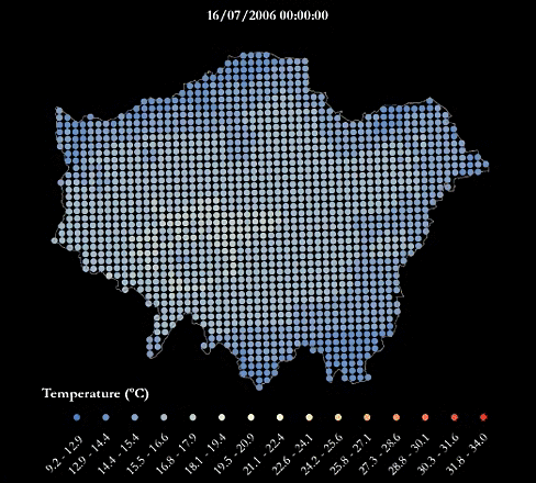
London’s Urban Heat Island - During A Warm Summer
- data.europa.eu
pdf, zip+ more versionsShareFacebookTwitterEmailClick to copy linkLink copiedCiteGreater London Authority, London’s Urban Heat Island - During A Warm Summer [Dataset]. https://data.europa.eu/data/datasets/londons-urban-heat-island-during-a-warm-summer?locale=lvpdf, zipAvailable download formatsDataset authored and provided byGreater London AuthorityArea coveredLondonDescriptionFor an urban heat island map during an average summer see this dataset.
A heatwave refers to a prolonged period of unusually hot weather. While there is no standard definition of a heatwave in England, the Met Office uses the World Meteorological Organization definition of a heatwave, which is "when the daily maximum temperature of more than five consecutive days exceeds the average maximum temperature by 5°C, the normal period being 1961-1990". They are common in the northern and southern hemisphere during summer have historically been associated with health problems and an increase in mortality.
The urban heat island (UHI) is the phenomenon where temperatures are relatively higher in cities compared to surrounding rural areas due to, for example, the urban surfaces and anthropogenic heat sources.
This urban heat island map was produced using LondUM, a specific set-up of the Met Office Unified Model version 6.1 for London. It uses the Met Office Reading Surface Exchange Scheme (MORUSES), as well as urban morphology data derived from Virtual London. The model was run from May until September 2006 and December 2006. This map shows average surface temperatures over the summer period of 2006 at a 1km by 1km resolution. To find out more about LondUM, see the University of Reading’s website.
The hourly outputs from LondUM have been aggregated and mapped by Jonathon Taylor, UCL Institute for Environmental Design and Engineering. Variables include:
- WSAVGMAX= the average of the maximum daily temperatures across the summer period (May 26th-August 31st)
- WSAVG=the average temperature across the summer period
- WSAVGMIN = the average minimum daily temperature across the summer period
- HWAVGMAX= the average of the maximum daily temperatures across the 2006 heatwave (July 16th-19th)
- HWAVG=the average temperature across the across the 2006 heatwave
- HWAVGMIN = the average minimum daily temperature across 2006 heatwave period
The maps are also available as one combined PDF.
The gif below maps the temperatures across London during the four-day period of 16-19th July, which was considered a heatwave.
If you make use of the LondUM data, please use the following citation to acknowledge the data and reference the publication below for model description:
LondUM (2011). Model data generated by Sylvia I. Bohnenstengel (*), Department of Meteorology, University of Reading and data retrieved from http://www.met.reading.ac.uk/~sws07sib/home/LondUM.html.
(*) Now at Metoffice@Reading, Email: sylvia.bohnenstengel@metoffice.gov.uk
Bohnenstengel SI, Evans S, Clark P and Belcher SeE (2011) Simulations of the London Urban Heat island. Quarterly journal of the Royal Meteorological Society, 137(659). pp. 1625-1640. ISSN 1477-870X doi 10.1002/qj.855. LondUM data (2013).
HadISDH.extremes: gridded global monthly land surface wet bulb and dry bulb...
- catalogue.ceda.ac.uk
Updated Jun 7, 2024+ more versionsShareFacebookTwitterEmailClick to copy linkLink copiedCiteKate M. Willett (2024). HadISDH.extremes: gridded global monthly land surface wet bulb and dry bulb temperature extremes index data version 1.0.0.2022f [Dataset]. https://catalogue.ceda.ac.uk/uuid/2d1613955e1b4cd1b156e5f3edbd7e66Dataset updatedJun 7, 2024AuthorsKate M. WillettLicenseOpen Government Licence 3.0http://www.nationalarchives.gov.uk/doc/open-government-licence/version/3/
License information was derived automaticallyTime period coveredJan 1, 1973 - Dec 31, 2022Area coveredEarthVariables measuredtime, latitude, longitudeDescriptionThis is the HadISDH.extremes 1.0.0.2022f version of the Met Office Hadley Centre Integrated Surface Dataset of Humidity (HadISDH). HadISDH.extremes is a near-global gridded monthly land surface extremes index climate monitoring product. It is created from in situ sub-daily observations of wet bulb (converted from dew point temperature) and dry bulb temperature from weather stations. The observations have been quality controlled at the hourly level with strict temporal completeness thresholds applied at daily, monthly, annual, climatological and whole period scales to minimise biases. Gridbox months are assessed for inhomogeneity and scores provided (see Homogeneity Score Document in Docs). The data are provided by the Met Office Hadley Centre and this version spans 1/1/1973 to 31/12/2022.
The data are monthly gridded (5 degree by 5 degree) fields. Products are available for 27 different heat extremes indices based on the ET-SCI (Expert Team on Sector-Specific Climate Indices; https://public.wmo.int/en/events/meetings/expert-team-sector-specific-climate-indices-et-sci) framework. These indices capture a range of moderate to severe extremes. They utilise the daily maximum and minimum values of sub-daily dry bulb and wet bulb temperature observations. Note that these will most likely underestimate the true extremes even when hourly data are available. The data are designed for assessing large scale features over long time scales, ideally using the anomaly fields as these are less affected by sampling biases. Users are advised to cross-compare with national datasets other supporting evidence when assessing small scale localised features.
This version is the first with annual updates envisaged. An update record will be maintained in the Docs section.
HadISD.3.3.0.2022f is the basis of HadISDH.extremes.
To keep informed about updates, news and announcements follow the HadOBS team on twitter @metofficeHadOBS.
For more detailed information e.g bug fixes, routine updates and other exploratory analysis, see the HadISDH blog: http://hadisdh.blogspot.co.uk/
References:
When using the dataset in a paper please cite the following papers (see Docs for link to the publications) and this dataset (using the "citable as" reference):
Willett, K, in press: HadISDH.extremes Part 1: a gridded wet bulb temperature extremes index product for climate monitoring. Advances in Atmospheric Sciences, doi: 10.1007/s00376-023-2347-8. http://www.iapjournals.ac.cn/aas/en/article/doi/10.1007/s00376-023-2347-8
Willett, K. in press: HadISDH.extremes Part 2: exploring humid heat extremes using wet bulb temperature indices. Advances in Atmospheric Sciences, doi: 10.1007/s00376-023-2348-7. http://www.iapjournals.ac.cn/aas/en/article/doi/10.1007/s00376-023-2348-7
Dunn, R. J. H., et al. 2016: Expanding HadISD: quality-controlled, sub-daily station data from 1931, Geoscientific Instrumentation, Methods and Data Systems, 5, 473-491. Smith, A., N. Lott, and R. Vose, 2011: The Integrated Surface Database: Recent Developments and Partnerships. Bulletin of the American Meteorological Society, 92, 704-708, doi:10.1175/2011BAMS3015.1
- u
Electrification of Heat Demonstration Project, 2020-2023
- datacatalogue.ukdataservice.ac.uk
Updated Dec 19, 2024+ more versionsShareFacebookTwitterEmailClick to copy linkLink copiedCiteEnergy Systems Catapult (2024). Electrification of Heat Demonstration Project, 2020-2023 [Dataset]. http://doi.org/10.5255/UKDA-SN-9050-2Unique identifierhttps://doi.org/10.5255/UKDA-SN-9050-2Dataset updatedDec 19, 2024AuthorsEnergy Systems CatapultArea coveredUnited KingdomDescriptionThe heat pump monitoring datasets are a key output of the Electrification of Heat Demonstration (EoH) project, a government-funded heat pump trial assessing the feasibility of heat pumps across the UK’s diverse housing stock. These datasets are provided in both cleansed and raw form and allow analysis of the initial performance of the heat pumps installed in the trial. From the datasets, insights such as heat pump seasonal performance factor (a measure of the heat pump's efficiency), heat pump performance during the coldest day of the year, and half-hourly performance to inform peak demand can be gleaned.
For the second edition (December 2024), the data were updated to include cleaned performance data collected between November 2020 and September 2023. The only documentation currently available with the study is the Excel data dictionary. Reports and other contextual information can be found on the Energy Systems Catapult website.
The EoH project was funded by the Department of Business, Energy and Industrial Strategy. From 2023, it is covered by the new Department for Energy Security and Net Zero.
Data availability
This study comprises the open-access cleansed data from the EoH project and a summary dataset, available in four zipped files (see the 'Access Data' tab). Users must download all four zip files to obtain the full set of cleansed data and accompanying documentation.
When unzipped, the full cleansed data comprises 742 CSV files. Most of the individual CSV files are too large to open in Excel. Users should ensure they have sufficient computing facilities to analyse the data.
The UKDS also holds an accompanying study, SN 9049 Electrification of Heat Demonstration Project: Heat Pump Performance Raw Data, 2020-2023, which is available only to registered UKDS users. This contains the raw data from the EoH project. Since the data are very large, only the summary dataset is available to download; an order must be placed for FTP delivery of the remaining raw data. Other studies in the set include SN 9209, which comprises 30-minute interval heat pump performance data, and SN 9210, which includes daily heat pump performance data.
The Python code used to cleanse the raw data and then perform the analysis is accessible via the "https://github.com/ES-Catapult/electrification_of_heat" target="_blank"> Energy Systems Catapult Github
Heat flow United Kingdom version 1
- ckan.publishing.service.gov.uk
- metadata.bgs.ac.uk
- +3more
Updated May 26, 2025ShareFacebookTwitterEmailClick to copy linkLink copiedCiteckan.publishing.service.gov.uk (2025). Heat flow United Kingdom version 1 [Dataset]. https://ckan.publishing.service.gov.uk/dataset/heat-flow-united-kingdom-version-1Dataset updatedMay 26, 2025Area coveredUnited KingdomDescriptionThe dataset portrays heat flow as a continuous modelled surface, interpolated between observation points. Onshore coverage is provided for England, Wales, Scotland and Northern Ireland. The British Geological Survey (BGS) Heat flow dataset version 1 (United Kingdom) is derived from a catalogue of legacy heat flow observations and ground-heat modelling. Heat flow data is typically used to determine temperatures beneath the ground surface, and model how much thermal energy may be stored in or recovered from the ground. The dataset is presented as a raster model, but is also available as cellular, vector grids. The raster and square-cellular grid defines each cell by an area of c. 4km2 (2km per side). The hexagonal-cellular defines each cell by an area of c. 2.56km2 (1km per side). Heat flow values are milli-Watts per square metre (mWm-2). The data are available under BGS data licence.
Annual Cooling Degree Days - Projections (12km)
- climatedataportal.metoffice.gov.uk
Updated May 17, 2023+ more versionsShareFacebookTwitterEmailClick to copy linkLink copiedCiteMet Office (2023). Annual Cooling Degree Days - Projections (12km) [Dataset]. https://climatedataportal.metoffice.gov.uk/datasets/annual-cooling-degree-days-projections-12kmDataset updatedMay 17, 2023Area coveredDescription[Updated 28/01/25 to fix an issue in the ‘Lower’ values, which were not fully representing the range of uncertainty. ‘Median’ and ‘Higher’ values remain unchanged. The size of the change varies by grid cell and fixed period/global warming levels but the average difference between the 'lower' values before and after this update is 1.2.]What does the data show? A Cooling Degree Day (CDD) is a day in which the average temperature is above 22°C. It is the number of degrees above this threshold that counts as a Coolin Degree Day. For example if the average temperature for a specific day is 22.5°C, this would contribute 0.5 Cooling Degree Days to the annual sum, alternatively an average temperature of 27°C would contribute 5 Cooling Degree Days. Given the data shows the annual sum of Cooling Degree Days, this value can be above 365 in some parts of the UK.Annual Cooling Degree Days is calculated for two baseline (historical) periods 1981-2000 (corresponding to 0.51°C warming) and 2001-2020 (corresponding to 0.87°C warming) and for global warming levels of 1.5°C, 2.0°C, 2.5°C, 3.0°C, 4.0°C above the pre-industrial (1850-1900) period. This enables users to compare the future number of CDD to previous values.What are the possible societal impacts?Cooling Degree Days indicate the energy demand for cooling due to hot days. A higher number of CDD means an increase in power consumption for cooling and air conditioning, therefore this index is useful for predicting future changes in energy demand for cooling.In practice, this varies greatly throughout the UK, depending on personal thermal comfort levels and building designs, so these results should be considered as rough estimates of overall demand changes on a large scale.What is a global warming level?Annual Cooling Degree Days are calculated from the UKCP18 regional climate projections using the high emissions scenario (RCP 8.5) where greenhouse gas emissions continue to grow. Instead of considering future climate change during specific time periods (e.g. decades) for this scenario, the dataset is calculated at various levels of global warming relative to the pre-industrial (1850-1900) period. The world has already warmed by around 1.1°C (between 1850–1900 and 2011–2020), whilst this dataset allows for the exploration of greater levels of warming. The global warming levels available in this dataset are 1.5°C, 2°C, 2.5°C, 3°C and 4°C. The data at each warming level was calculated using a 21 year period. These 21 year periods are calculated by taking 10 years either side of the first year at which the global warming level is reached. This time will be different for different model ensemble members. To calculate the value for the Annual Cooling Degree Days, an average is taken across the 21 year period. Therefore, the Annual Cooling Degree Days show the number of cooling degree days that could occur each year, for each given level of warming. We cannot provide a precise likelihood for particular emission scenarios being followed in the real world future. However, we do note that RCP8.5 corresponds to emissions considerably above those expected with current international policy agreements. The results are also expressed for several global warming levels because we do not yet know which level will be reached in the real climate as it will depend on future greenhouse emission choices and the sensitivity of the climate system, which is uncertain. Estimates based on the assumption of current international agreements on greenhouse gas emissions suggest a median warming level in the region of 2.4-2.8°C, but it could either be higher or lower than this level.What are the naming conventions and how do I explore the data?This data contains a field for each global warming level and two baselines. They are named ‘CDD’ (Cooling Degree Days), the warming level or baseline, and 'upper' 'median' or 'lower' as per the description below. E.g. 'CDD 2.5 median' is the median value for the 2.5°C projection. Decimal points are included in field aliases but not field names e.g. 'CDD 2.5 median' is 'CDD_25_median'. To understand how to explore the data, see this page: https://storymaps.arcgis.com/stories/457e7a2bc73e40b089fac0e47c63a578Please note, if viewing in ArcGIS Map Viewer, the map will default to ‘CDD 2.0°C median’ values.What do the ‘median’, ‘upper’, and ‘lower’ values mean?Climate models are numerical representations of the climate system. To capture uncertainty in projections for the future, an ensemble, or group, of climate models are run. Each ensemble member has slightly different starting conditions or model set-ups. Considering all of the model outcomes gives users a range of plausible conditions which could occur in the future. For this dataset, the model projections consist of 12 separate ensemble members. To select which ensemble members to use, Annual Cooling Degree Days were calculated for each ensemble member and they were then ranked in order from lowest to highest for each location. The ‘lower’ fields are the second lowest ranked ensemble member. The ‘upper’ fields are the second highest ranked ensemble member. The ‘median’ field is the central value of the ensemble.This gives a median value, and a spread of the ensemble members indicating the range of possible outcomes in the projections. This spread of outputs can be used to infer the uncertainty in the projections. The larger the difference between the lower and upper fields, the greater the uncertainty.‘Lower’, ‘median’ and ‘upper’ are also given for the baseline periods as these values also come from the model that was used to produce the projections. This allows a fair comparison between the model projections and recent past. Useful linksThis dataset was calculated following the methodology in the ‘Future Changes to high impact weather in the UK’ report and uses the same temperature thresholds as the 'State of the UK Climate' report.Further information on the UK Climate Projections (UKCP).Further information on understanding climate data within the Met Office Climate Data Portal.
Monthly Rainfall and Temperatures (UK)
- kaggle.com
zipUpdated Jan 18, 2023ShareFacebookTwitterEmailClick to copy linkLink copiedCiteThe Devastator (2023). Monthly Rainfall and Temperatures (UK) [Dataset]. https://www.kaggle.com/datasets/thedevastator/monthly-average-rainfall-and-temperature-in-nortzip(5255 bytes)Available download formatsDataset updatedJan 18, 2023AuthorsThe DevastatorLicensehttps://creativecommons.org/publicdomain/zero/1.0/https://creativecommons.org/publicdomain/zero/1.0/
Area coveredUnited KingdomDescriptionMonthly Rainfall and Temperatures (UK)
Met Office Climate District
By data.world's Admin [source]
About this dataset
More Datasets
For more datasets, click here.
Featured Notebooks
- 🚨 Your notebook can be here! 🚨!
How to use the dataset
To use this dataset, start by making sure you are familiar with the following fields: OrganisationName, OrganisationCode, PublishedDate, DurationFrom (start date of reported period), DurationTo (end date of reported period), LatestData (indicating if latest available data is provided or not), GeoName (name of geographical area being reported on), ReportingPeriodType (type of reporting period i.e monthly/yearly/seasonal etc.), Year, Rainfallmm(average rainfall in millimeters), Temp(average temperature in centigrade), Dataset Name(name of the dataset provided). These are all important pieces of information that must be known before delving into the other columns.
Research Ideas
- Developing predictive models for drought and flooding with the help of average temperature and rainfall data
- Producing reports to inform farmers on various farming activities that need to be done depending on the climate conditions in the region
- Creating visualizations which can compare historical trends of average temperature and rainfall in different regions
Acknowledgements
If you use this dataset in your research, please credit the original authors. Data Source
License
License: CC0 1.0 Universal (CC0 1.0) - Public Domain Dedication No Copyright - You can copy, modify, distribute and perform the work, even for commercial purposes, all without asking permission. See Other Information.
Columns
File: average-rainfall-temperature-1.csv | Column name | Description | |:------------------------|:--------------------------------------------------------------------------------| | OrganisationName | Name of the organisation providing the data. (String) | | OrganisationCode | Code associated with the name of the organisation providing the data. (String) | | PublishedDate | Date when that particular set of data was published. (Date) | | DurationFrom | Start date of that respective period. (Date) | | DurationTo | End date of the respective period. (Date) | | LatestData | It specifies whether or not that particular set is available to you. (Boolean) | | GeoName | Place/location where these climatic conditions exists. (String) | | ReportingPeriodType | Specifies whether it is a monthly/yearly report. (String) | | Year | Indicates year for which these statistical values have been obtained. (Integer) | | Rainfallmm | Average rainfall in millimetres during specified period. (Float) | | Temp | Average temperature in centigrade during specified period. (Float) |
File: average-rainfall-temperature-metatdata-2.csv | Column name | Description | |:--------------------------------------------|:-------------------------------------------------------------------------------------------------------------------------------------------------------------------| | Dataset Name | Name of the dataset. (String) | | Field | Details a certain aspect or parameter amongst numerous parameters present within a resultset. (String) | | Type | Whether its Numerical value or DoT notation. (String) | | Mandatory or Optional requirement (MOR) | This field tells us if we require anything specific while submitting our queries. (String) | | Field Description | A brief overvie...
UKCP09: Gridded Datasets of Annual values of Winter (November-April)...
- ckan.publishing.service.gov.uk
Updated Jan 26, 2011+ more versionsShareFacebookTwitterEmailClick to copy linkLink copiedCiteckan.publishing.service.gov.uk (2011). UKCP09: Gridded Datasets of Annual values of Winter (November-April) heatwave duration (days) - Dataset - data.gov.uk [Dataset]. https://ckan.publishing.service.gov.uk/dataset/ukcp09-gridded-annual-datasets-of-winter-nov-apr-heatwave-duration-daysDataset updatedJan 26, 2011DescriptionUKCP09: Gridded datasets of annual values.Winter heatwave duration. The day-by-day sum of the mean number of degrees by which the air temperature is more than a value of 22 °C As summer heat wave but for November–April. The datasets have been created with financial support from the Department for Environment, Food and Rural Affairs (Defra) and they are being promoted by the UK Climate Impacts Programme (UKCIP) as part of the UK Climate Projections (UKCP09). http://ukclimateprojections.defra.gov.uk/content/view/12/689/. To view this data you will have to register on the Met Office website, here: http://www.metoffice.gov.uk/research/climate/climate-monitoring/UKCP09/register
Regional climate values for Maximum Temperature - Dataset - data.gov.uk
- ckan.publishing.service.gov.uk
Updated Feb 24, 2011+ more versionsShareFacebookTwitterEmailClick to copy linkLink copiedCiteckan.publishing.service.gov.uk (2011). Regional climate values for Maximum Temperature - Dataset - data.gov.uk [Dataset]. https://ckan.publishing.service.gov.uk/dataset/regional-climate-values-for-maximum-temperatureDataset updatedFeb 24, 2011LicenseOpen Government Licence 3.0http://www.nationalarchives.gov.uk/doc/open-government-licence/version/3/
License information was derived automaticallyDescriptionRegional climate values for an element, ordered by year -Max Temp. Allowances have been made for topographic, coastal and urban effects where relationships are found to exist. Seasons: Winter=Dec-Feb, Spring=Mar-May, Summer=June-Aug, Autumn=Sept-Nov. (Winter: Year refers to Jan/Feb).
- n
ESA Land Surface Temperature Climate Change Initiative (LST_cci): Monthly...
- data-search.nerc.ac.uk
- catalogue.ceda.ac.uk
Updated Mar 6, 2022+ more versionsShareFacebookTwitterEmailClick to copy linkLink copiedCite(2022). ESA Land Surface Temperature Climate Change Initiative (LST_cci): Monthly land surface temperature from SLSTR (Sea and Land Surface Temperature Radiometer) on Sentinel 3B, level 3 collated (L3C) global product (2018-2020), version 3.00 [Dataset]. https://data-search.nerc.ac.uk/geonetwork/srv/search?keyword=SLSTRDataset updatedMar 6, 2022DescriptionThis dataset contains monthly-averaged land surface temperatures (LSTs) and their uncertainty estimates from the Sea and Land Surface Temperature Radiometer (SLSTR) on Sentinel 3B. Satellite land surface temperatures are skin temperatures, which means, for example, the temperature of the ground surface in bare soil areas, the temperature of the canopy over forests, and a mix of the soil and leaf temperature over sparse vegetation. The skin temperature is an important variable when considering surface fluxes of, for instance, heat and water. Daytime and night-time temperatures are provided in separate files corresponding to the morning and evening Sentinel 3B equator crossing times which are 10:00 and 22:00 local solar time. Per pixel uncertainty estimates are given in two forms, first, an estimate of the total uncertainty for the pixel and second, a breakdown of the uncertainty into components by correlation length. Also provided in the files, on a per pixel basis, are the observation time, the satellite viewing and solar geometry angles, a quality flag, and land cover class. The dataset coverage is global over the land surface. LSTs are provided on a global equal angle grid at a resolution of 0.01° longitude and 0.01° latitude. SLSTRB achieves full Earth coverage in 1 day so the daily files have gaps where the surface is not covered by the satellite swath during day or night on that day. Furthermore, LSTs are not produced where clouds are present since under these circumstances the IR radiometer observes the cloud top which is usually much colder than the surface. Dataset coverage runs from December 2018 to December 2020. There are minor interruptions (1-10 days) during satellite/instrument maintenance periods or instrument anomalies. The dataset was produced by the University of Leicester (UoL) and LSTs were retrieved using the (UoL) LST retrieval algorithm and data were processed in the UoL processing chain. The dataset was produced as part of the ESA Land Surface Temperature Climate Change Initiative which strives to improve satellite datasets to Global Climate Observing System (GCOS) standards.
Excess mortality during heat-periods, England and Wales
- ons.gov.uk
- cy.ons.gov.uk
xlsxUpdated Oct 7, 2022ShareFacebookTwitterEmailClick to copy linkLink copiedCiteOffice for National Statistics (2022). Excess mortality during heat-periods, England and Wales [Dataset]. https://www.ons.gov.uk/peoplepopulationandcommunity/birthsdeathsandmarriages/deaths/datasets/excessmortalityduringheatperiodsenglandandwalesxlsxAvailable download formatsDataset updatedOct 7, 2022LicenseOpen Government Licence 3.0http://www.nationalarchives.gov.uk/doc/open-government-licence/version/3/
License information was derived automaticallyArea coveredEnglandDescriptionExcess deaths occurring during heat-periods, including breakdowns by sex, age group, cause of death, place of occurrence and geography.
Annual Count of Tropical Nights - Projections (12km)
- climatedataportal.metoffice.gov.uk
Updated Feb 7, 2023ShareFacebookTwitterEmailClick to copy linkLink copiedCiteMet Office (2023). Annual Count of Tropical Nights - Projections (12km) [Dataset]. https://climatedataportal.metoffice.gov.uk/datasets/TheMetOffice::annual-count-of-tropical-nights-projections-12km/exploreDataset updatedFeb 7, 2023Area coveredDescription[Updated 28/01/25 to fix an issue in the ‘Lower’ values, which were not fully representing the range of uncertainty. ‘Median’ and ‘Higher’ values remain unchanged. The size of the change varies by grid cell and fixed period/global warming levels but the average difference between the 'lower' values before and after this update is 0.0.]What does the data show? The Annual Count of Tropical Nights is the number of days per year where the minimum daily temperature is above 20°C. It measures how many times the threshold is exceeded (not by how much). It measures how many times the threshold is exceeded (not by how much) in a year. The results should be interpreted as an approximation of the projected number of days when the threshold is exceeded as there will be many factors such as natural variability and local scale processes that the climate model is unable to represent.The Annual Count of Tropical Nights is calculated for two baseline (historical) periods 1981-2000 (corresponding to 0.51°C warming) and 2001-2020 (corresponding to 0.87°C warming) and for global warming levels of 1.5°C, 2.0°C, 2.5°C, 3.0°C, 4.0°C above the pre-industrial (1850-1900) period. This enables users to compare the future number of tropical nights to previous values. What are the possible societal impacts?The Annual Count of Tropical Nights indicates increased health risks and heat stress due to high night-time temperatures. It is based on exceeding a minimum daily temperature of 20°C, i.e. the temperature does not fall below 20°C for the entire day. Impacts include:Increased heat related illnesses, hospital admissions or death for vulnerable people.Increased heat stress, it is important the body has time to recover from high daytime temperatures during the lower temperatures at night.Other metrics such as the Annual Count of Summer Days (days above 25°C), Annual Count of Hot Summer Days (days above 30°C) and the Annual Count of Extreme Summer Days (days above 35°C) also indicate impacts from high temperatures, however they use different temperature thresholds.What is a global warming level?The Annual Count of Tropical Nights is calculated from the UKCP18 regional climate projections using the high emissions scenario (RCP 8.5) where greenhouse gas emissions continue to grow. Instead of considering future climate change during specific time periods (e.g. decades) for this scenario, the dataset is calculated at various levels of global warming relative to the pre-industrial (1850-1900) period. The world has already warmed by around 1.1°C (between 1850–1900 and 2011–2020), whilst this dataset allows for the exploration of greater levels of warming.The global warming levels available in this dataset are 1.5°C, 2°C, 2.5°C, 3°C and 4°C. The data at each warming level was calculated using a 21 year period. These 21 year periods are calculated by taking 10 years either side of the first year at which the global warming level is reached. This time will be different for different model ensemble members. To calculate the value for the Annual Count of Tropical Nights, an average is taken across the 21 year period. Therefore, the Annual Count of Tropical Nights show the number of tropical nights that could occur each year, for each given level of warming. We cannot provide a precise likelihood for particular emission scenarios being followed in the real world future. However, we do note that RCP8.5 corresponds to emissions considerably above those expected with current international policy agreements. The results are also expressed for several global warming levels because we do not yet know which level will be reached in the real climate as it will depend on future greenhouse emission choices and the sensitivity of the climate system, which is uncertain. Estimates based on the assumption of current international agreements on greenhouse gas emissions suggest a median warming level in the region of 2.4-2.8°C, but it could either be higher or lower than this level.What are the naming conventions and how do I explore the data?This data contains a field for each global warming level and two baselines. They are named ‘Tropical Nights’, the warming level or baseline, and ‘upper’ ‘median’ or ‘lower’ as per the description below. E.g. ‘Tropical Nights 2.5 median’ is the median value for the 2.5°C warming level. Decimal points are included in field aliases but not field names e.g. ‘Tropical Nights 2.5 median’ is ‘TropicalNights_25_median’. To understand how to explore the data, see this page: https://storymaps.arcgis.com/stories/457e7a2bc73e40b089fac0e47c63a578Please note, if viewing in ArcGIS Map Viewer, the map will default to ‘Tropical Nights 2.0°C median’ values.What do the ‘median’, ‘upper’, and ‘lower’ values mean?Climate models are numerical representations of the climate system. To capture uncertainty in projections for the future, an ensemble, or group, of climate models are run. Each ensemble member has slightly different starting conditions or model set-ups. Considering all of the model outcomes gives users a range of plausible conditions which could occur in the future. For this dataset, the model projections consist of 12 separate ensemble members. To select which ensemble members to use, the Annual Count of Tropical Nights was calculated for each ensemble member and they were then ranked in order from lowest to highest for each location. The ‘lower’ fields are the second lowest ranked ensemble member. The ‘upper’ fields are the second highest ranked ensemble member. The ‘median’ field is the central value of the ensemble.This gives a median value, and a spread of the ensemble members indicating the range of possible outcomes in the projections. This spread of outputs can be used to infer the uncertainty in the projections. The larger the difference between the lower and upper fields, the greater the uncertainty.‘Lower’, ‘median’ and ‘upper’ are also given for the baseline periods as these values also come from the model that was used to produce the projections. This allows a fair comparison between the model projections and recent past. Useful linksThis dataset was calculated following the methodology in the ‘Future Changes to high impact weather in the UK’ report and uses the same temperature thresholds as the 'State of the UK Climate' report.Further information on the UK Climate Projections (UKCP).Further information on understanding climate data within the Met Office Climate Data Portal.
Monthly average daily temperatures in the United Kingdom 2015-2024
- statista.com
Updated Dec 15, 2024ShareFacebookTwitterEmailClick to copy linkLink copiedCiteStatista (2024). Monthly average daily temperatures in the United Kingdom 2015-2024 [Dataset]. https://www.statista.com/statistics/322658/monthly-average-daily-temperatures-in-the-united-kingdom-uk/Dataset updatedDec 15, 2024Time period coveredJan 2015 - Nov 2024Area coveredUnited KingdomDescriptionThe highest average temperature recorded in 2024 until November was in August, at 16.8 degrees Celsius. Since 2015, the highest average daily temperature in the UK was registered in July 2018, at 18.7 degrees Celsius. The summer of 2018 was the joint hottest since institutions began recording temperatures in 1910. One noticeable anomaly during this period was in December 2015, when the average daily temperature reached 9.5 degrees Celsius. This month also experienced the highest monthly rainfall in the UK since before 2014, with England, Wales, and Scotland suffering widespread flooding. Daily hours of sunshine Unsurprisingly, the heat wave that spread across the British Isles in 2018 was the result of particularly sunny weather. July 2018 saw an average of 8.7 daily sun hours in the United Kingdom. This was more hours of sun than was recorded in July 2024, which only saw 5.8 hours of sun. Temperatures are on the rise Since the 1960s, there has been an increase in regional temperatures across the UK. Between 1961 and 1990, temperatures in England averaged nine degrees Celsius, and from 2013 to 2022, average temperatures in the country had increased to 10.3 degrees Celsius. Due to its relatively southern location, England continues to rank as the warmest country in the UK.
Heat flow United Kingdom Web service
- ckan.publishing.service.gov.uk
Updated Nov 26, 2025ShareFacebookTwitterEmailClick to copy linkLink copiedCiteThe citation is currently not available for this dataset.Dataset updatedNov 26, 2025Area coveredUnited KingdomDescriptionThis Web service provides the BGS heat flow dataset as a Web Map Service (WMS). The British Geological Survey (BGS) heat flow model (United Kingdom) is derived from a catalogue of legacy heat flow data points and ground-heat modelling. The model portrays heat flow as a continuous modelled surface, interpolated between observation and estimation points. Heat flow data is typically used to determine temperatures beneath the ground surface, and model how much thermal energy may be recovered from or stored within.
Annual Count of Frost Days - Projections (12km)
- climatedataportal.metoffice.gov.uk
Updated Feb 7, 2023ShareFacebookTwitterEmailClick to copy linkLink copiedCiteMet Office (2023). Annual Count of Frost Days - Projections (12km) [Dataset]. https://climatedataportal.metoffice.gov.uk/datasets/annual-count-of-frost-days-projections-12kmDataset updatedFeb 7, 2023Area coveredDescription[Updated 28/01/25 to fix an issue in the ‘Lower’ values, which were not fully representing the range of uncertainty. ‘Median’ and ‘Higher’ values remain unchanged. The size of the change varies by grid cell and fixed period/global warming levels but the average difference between the 'lower' values before and after this update is 1.2.]What does the data show? The Annual Count of Frost Days is the number of days per year where the minimum daily temperature is below 0°C. It measures how many times the threshold is exceeded (not by how much) in a year. The results should be interpreted as an approximation of the projected number of days when the threshold is exceeded as there will be many factors such as natural variability and local scale processes that the climate model is unable to represent.The Annual Count of Frost Days is calculated for two baseline (historical) periods 1981-2000 (corresponding to 0.51°C warming) and 2001-2020 (corresponding to 0.87°C warming) and for global warming levels of 1.5°C, 2.0°C, 2.5°C, 3.0°C, 4.0°C above the pre-industrial (1850-1900) period. This enables users to compare the future number of frost days to previous values. What are the possible societal impacts?The Annual Count of Frost Days indicates increased cold weather disruption due to a higher than normal chance of ice and snow. It is based on the minimum daily temperature being below 0°C. Impacts include:Damage to crops.Transport disruption.Increased energy demand.The Annual Count of Icing Days, is a similar metric measuring impacts from cold temperatures, it indicates more severe cold weather impacts.What is a global warming level?The Annual Count of Frost Days is calculated from the UKCP18 regional climate projections using the high emissions scenario (RCP 8.5) where greenhouse gas emissions continue to grow. Instead of considering future climate change during specific time periods (e.g. decades) for this scenario, the dataset is calculated at various levels of global warming relative to the pre-industrial (1850-1900) period. The world has already warmed by around 1.1°C (between 1850–1900 and 2011–2020), whilst this dataset allows for the exploration of greater levels of warming. The global warming levels available in this dataset are 1.5°C, 2°C, 2.5°C, 3°C and 4°C. The data at each warming level was calculated using a 21 year period. These 21 year periods are calculated by taking 10 years either side of the first year at which the global warming level is reached. This time will be different for different model ensemble members. To calculate the value for the Annual Count of Frost Days, an average is taken across the 21 year period. Therefore, the Annual Count of Frost Days show the number of frost days that could occur each year, for each given level of warming. We cannot provide a precise likelihood for particular emission scenarios being followed in the real world future. However, we do note that RCP8.5 corresponds to emissions considerably above those expected with current international policy agreements. The results are also expressed for several global warming levels because we do not yet know which level will be reached in the real climate as it will depend on future greenhouse emission choices and the sensitivity of the climate system, which is uncertain. Estimates based on the assumption of current international agreements on greenhouse gas emissions suggest a median warming level in the region of 2.4-2.8°C, but it could either be higher or lower than this level.What are the naming conventions and how do I explore the data?This data contains a field for each global warming level and two baselines. They are named ‘Frost Days’, the warming level or baseline, and ‘upper’ ‘median’ or ‘lower’ as per the description below. E.g. ‘Frost Days 2.5 median’ is the median value for the 2.5°C warming level. Decimal points are included in field aliases but not field names e.g. ‘Frost Days 2.5 median’ is ‘FrostDays_25_median’. To understand how to explore the data, see this page: https://storymaps.arcgis.com/stories/457e7a2bc73e40b089fac0e47c63a578Please note, if viewing in ArcGIS Map Viewer, the map will default to ‘Frost Days 2.0°C median’ values.What do the ‘median’, ‘upper’, and ‘lower’ values mean?Climate models are numerical representations of the climate system. To capture uncertainty in projections for the future, an ensemble, or group, of climate models are run. Each ensemble member has slightly different starting conditions or model set-ups. Considering all of the model outcomes gives users a range of plausible conditions which could occur in the future. For this dataset, the model projections consist of 12 separate ensemble members. To select which ensemble members to use, the Annual Count of Frost Days was calculated for each ensemble member and they were then ranked in order from lowest to highest for each location. The ‘lower’ fields are the second lowest ranked ensemble member. The ‘upper’ fields are the second highest ranked ensemble member. The ‘median’ field is the central value of the ensemble.This gives a median value, and a spread of the ensemble members indicating the range of possible outcomes in the projections. This spread of outputs can be used to infer the uncertainty in the projections. The larger the difference between the lower and upper fields, the greater the uncertainty.‘Lower’, ‘median’ and ‘upper’ are also given for the baseline periods as these values also come from the model that was used to produce the projections. This allows a fair comparison between the model projections and recent past. Useful linksThis dataset was calculated following the methodology in the ‘Future Changes to high impact weather in the UK’ report and uses the same temperature thresholds as the 'State of the UK Climate' report.Further information on the UK Climate Projections (UKCP).Further information on understanding climate data within the Met Office Climate Data Portal.
 FacebookTwitter
[Updated 28/01/25 to fix an issue in the ‘Lower’ values, which were not fully representing the range of uncertainty. ‘Median’ and ‘Higher’ values remain unchanged. The size of the change varies by grid cell and fixed period/global warming levels but the average difference between the 'lower' values before and after this update is 0.2.]What does the data show? The Annual Count of Hot Summer Days is the number of days per year where the maximum daily temperature is above 30°C. It measures how many times the threshold is exceeded (not by how much) in a year. Note, the term ‘hot summer days’ is used to refer to the threshold and temperatures above 30°C outside the summer months also contribute to the annual count. The results should be interpreted as an approximation of the projected number of days when the threshold is exceeded as there will be many factors such as natural variability and local scale processes that the climate model is unable to represent.The Annual Count of Hot Summer Days is calculated for two baseline (historical) periods 1981-2000 (corresponding to 0.51°C warming) and 2001-2020 (corresponding to 0.87°C warming) and for global warming levels of 1.5°C, 2.0°C, 2.5°C, 3.0°C, 4.0°C above the pre-industrial (1850-1900) period. This enables users to compare the future number of hot summer days to previous values.What are the possible societal impacts?The Annual Count of Hot Summer Days indicates increased health risks, transport disruption and damage to infrastructure from high temperatures. It is based on exceeding a maximum daily temperature of 30°C. Impacts include:Increased heat related illnesses, hospital admissions or death.Transport disruption due to overheating of railway infrastructure. Overhead power lines also become less efficient. Other metrics such as the Annual Count of Summer Days (days above 25°C), Annual Count of Extreme Summer Days (days above 35°C) and the Annual Count of Tropical Nights (where the minimum temperature does not fall below 20°C) also indicate impacts from high temperatures, however they use different temperature thresholds.What is a global warming level?The Annual Count of Hot Summer Days is calculated from the UKCP18 regional climate projections using the high emissions scenario (RCP 8.5) where greenhouse gas emissions continue to grow. Instead of considering future climate change during specific time periods (e.g. decades) for this scenario, the dataset is calculated at various levels of global warming relative to the pre-industrial (1850-1900) period. The world has already warmed by around 1.1°C (between 1850–1900 and 2011–2020), whilst this dataset allows for the exploration of greater levels of warming. The global warming levels available in this dataset are 1.5°C, 2°C, 2.5°C, 3°C and 4°C. The data at each warming level was calculated using a 21 year period. These 21 year periods are calculated by taking 10 years either side of the first year at which the global warming level is reached. This time will be different for different model ensemble members. To calculate the value for the Annual Count of Hot Summer Days, an average is taken across the 21 year period. Therefore, the Annual Count of Hot Summer Days show the number of hot summer days that could occur each year, for each given level of warming. We cannot provide a precise likelihood for particular emission scenarios being followed in the real world future. However, we do note that RCP8.5 corresponds to emissions considerably above those expected with current international policy agreements. The results are also expressed for several global warming levels because we do not yet know which level will be reached in the real climate as it will depend on future greenhouse emission choices and the sensitivity of the climate system, which is uncertain. Estimates based on the assumption of current international agreements on greenhouse gas emissions suggest a median warming level in the region of 2.4-2.8°C, but it could either be higher or lower than this level.What are the naming conventions and how do I explore the data?This data contains a field for each global warming level and two baselines. They are named ‘HSD’ (where HSD means Hot Summer Days), the warming level or baseline, and ‘upper’ ‘median’ or ‘lower’ as per the description below. E.g. ‘Hot Summer Days 2.5 median’ is the median value for the 2.5°C warming level. Decimal points are included in field aliases but not field names e.g. ‘Hot Summer Days 2.5 median’ is ‘HotSummerDays_25_median’. To understand how to explore the data, see this page: https://storymaps.arcgis.com/stories/457e7a2bc73e40b089fac0e47c63a578Please note, if viewing in ArcGIS Map Viewer, the map will default to ‘HSD 2.0°C median’ values.What do the ‘median’, ‘upper’, and ‘lower’ values mean?Climate models are numerical representations of the climate system. To capture uncertainty in projections for the future, an ensemble, or group, of climate models are run. Each ensemble member has slightly different starting conditions or model set-ups. Considering all of the model outcomes gives users a range of plausible conditions which could occur in the future. For this dataset, the model projections consist of 12 separate ensemble members. To select which ensemble members to use, the Annual Count of Hot Summer Days was calculated for each ensemble member and they were then ranked in order from lowest to highest for each location. The ‘lower’ fields are the second lowest ranked ensemble member. The ‘upper’ fields are the second highest ranked ensemble member. The ‘median’ field is the central value of the ensemble.This gives a median value, and a spread of the ensemble members indicating the range of possible outcomes in the projections. This spread of outputs can be used to infer the uncertainty in the projections. The larger the difference between the lower and upper fields, the greater the uncertainty.‘Lower’, ‘median’ and ‘upper’ are also given for the baseline periods as these values also come from the model that was used to produce the projections. This allows a fair comparison between the model projections and recent past. Useful linksThis dataset was calculated following the methodology in the ‘Future Changes to high impact weather in the UK’ report and uses the same temperature thresholds as the 'State of the UK Climate' report.Further information on the UK Climate Projections (UKCP).Further information on understanding climate data within the Met Office Climate Data Portal.