- N
OSE/ISC Real-Time Water Measurement Information System
- catalog.newmexicowaterdata.org
api, html +1Updated Oct 22, 2024 Share
Share Facebook
 Twitter
 EmailClick to copy linkLink copiedCiteNew Mexico Office of the State Engineer & Interstate Stream Commission (2024). OSE/ISC Real-Time Water Measurement Information System [Dataset]. https://catalog.newmexicowaterdata.org/dataset/ose-isc-real-time-water-measurement-information-systemapi, html, sensorthings apiAvailable download formatsDataset updatedOct 22, 2024Dataset provided byNew Mexico Office of the State Engineer & Interstate Stream CommissionLicense
Open Data Commons Attribution License (ODC-By) v1.0https://www.opendatacommons.org/licenses/by/1.0/
License information was derived automaticallyDescriptionOSE/ISC maintains a network of stream, acequia, ditch and well monitoring sites that electronically transmits data values via radio and satellite telemetry and stores the data in a database. This real-time water measurement data is available for each active gage/well shown on select basin maps.
- N
Finding the neural correlates of collaboration using a three-person fMRI...
- neurovault.org
niftiUpdated Jun 30, 2020+ more versionsShareFacebookTwitterEmailClick to copy linkLink copiedCite(2020). Finding the neural correlates of collaboration using a three-person fMRI hyperscanning paradigm: avg ISC map [Dataset]. http://identifiers.org/neurovault.image:394807niftiAvailable download formatsUnique identifierhttps://identifiers.org/neurovault.image:394807Dataset updatedJun 30, 2020LicenseCC0 1.0 Universal Public Domain Dedicationhttps://creativecommons.org/publicdomain/zero/1.0/
License information was derived automaticallyDescriptionGroup averaged intersubject correlation (ISC) during collaboration phase
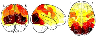
Collection description
The collaborative 3-person Pictionary task is a multi-player version of the Pictionary game [1]. The goal of the task is to draw a verb independently and collectively for others to guess. Nine verbs were drawn over three runs. The drawing of each verb can be split into three phases: independent phase (two blocks), evaluation phase (one block), and the collaboration phase (three blocks). Each block lasted for 30s, and was separated by a fixation period jittering around 7-8s.
Ref[1]: Xie, Hua, et al. "Finding the neural correlates of collaboration using a three-person fMRI hyperscanning paradigm." bioRxiv (2019): 782870.Subject species
homo sapiens
Modality
fMRI-BOLD
Analysis level
group
Cognitive paradigm (task)
drawing
Map type
Other
- r
2010 Index of Stream Condition - Bank Full Width 100m Section Summary Table
- researchdata.edu.au
Updated Sep 30, 2021+ more versionsShareFacebookTwitterEmailClick to copy linkLink copiedCitedata.vic.gov.au (2021). 2010 Index of Stream Condition - Bank Full Width 100m Section Summary Table [Dataset]. https://researchdata.edu.au/2010-index-stream-summary-table/1770960Dataset updatedSep 30, 2021Dataset provided bydata.vic.gov.auLicenseAttribution 4.0 (CC BY 4.0)https://creativecommons.org/licenses/by/4.0/
License information was derived automaticallyDescriptionThe ISC_BANKFULL_WIDTH_S table is the Statistical Summary table for the Bankfull Width metric at the 100m Section level.
River condition in Victoria is assessed every 5 years using the Index of Stream Condition (ISC). The Department of Environment and Primary Industries (DEPI) developed a methodology to assess the Physical Form and Riparian Vegetation components of the ISC using remote sensing data, specifically LIDAR and aerial photography.
A State Wide mapping project was undertaken in 2010-13 to accurately map the Physical Form and Riparian Vegetation metrics of the ISC . Other ISC metrics were not assessed in the project and were derived from other sources.
The Physical Form and Riparian Vegetation Metric products are a combination of mapped Vector and Raster data as well as Tabular Summary Statistics about the mapped features. In the context of the project, the term Metrics is used to refer to both the mapped features and the summary statistics.
Remote sensing data used includes 15cm true colour and infra-red aerial photography and four return multi-pulse LiDAR data. This source data was used to derive a variety of Raster data sets including Digital Terrain Models, Slope, Vegetation Height and Vegetation Cover. The Digital Terrain and Slope rasters were used to map Physical Form metrics including Stream Bed, Top of Bank and River Centre Lines while the Vegetation Height and Cover rasters were used to map the Riparian Vegetation metrics. The Project Report "Aerial Remote Sensing for Physical Channel Form and Riparian Vegetation Mapping" describes the remote sensing and mapping approach used to create this data set.
- N
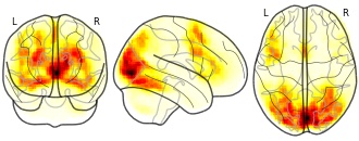
How Many Is Enough? Effect of Sample Size in Inter-Subject Correlation...
- neurovault.org
niftiUpdated Jun 30, 2018+ more versionsShareFacebookTwitterEmailClick to copy linkLink copiedCite(2018). How Many Is Enough? Effect of Sample Size in Inter-Subject Correlation Analysis of fMRI: VarMap 20Subj [Dataset]. http://identifiers.org/neurovault.image:11591niftiAvailable download formatsUnique identifierhttps://identifiers.org/neurovault.image:11591Dataset updatedJun 30, 2018LicenseCC0 1.0 Universal Public Domain Dedicationhttps://creativecommons.org/publicdomain/zero/1.0/
License information was derived automaticallyDescriptionISCtoolbox
Collection description
Statistical maps from testing the proper sample size in ISC analysis with ISCtoolbox for Matlab.
CorrMap_XXSubj maps define the average paired correlation from 1000 tests for subject groups of 10 to 65 subjects
MaeMap_XXSubj maps define the average paired MAE from 1000 tests for subject groups of 10 to 65 subjects
VarMap_XXSubj maps define the average paired Variance from 1000 tests for subject groups of 10 to 65 subjectsISCcorrmapBand0Session1.nii has the statistical map of basic ISC analysis for the full data set of 130 subjects with Verbal Generation task from Functional Reference Battery of ICBM.
Subject species
homo sapiens
Map type
Other
- w
2010 Index of Stream Condition - Toe of Bank line features
- data.wu.ac.at
wmsUpdated Jul 21, 2018+ more versionsShareFacebookTwitterEmailClick to copy linkLink copiedCiteDepartment of Environment, Land, Water & Planning (2018). 2010 Index of Stream Condition - Toe of Bank line features [Dataset]. https://data.wu.ac.at/schema/www_data_vic_gov_au/NWI1NDVkY2QtNzI1OS00OWI3LWE2MmEtYTRkNjBhODJmYjg3wmsAvailable download formatsDataset updatedJul 21, 2018Dataset provided byDepartment of Environment, Land, Water & PlanningLicenseAttribution 4.0 (CC BY 4.0)https://creativecommons.org/licenses/by/4.0/
License information was derived automaticallyArea covered71ab36a85084d8e9e4ffa2922535b9c732132e4fDescriptionThe ISC2010_TOE_OF_BANK line features represent the left and right stream bed lines of the river channel for each River Reach.
River condition in Victoria is assessed every 5 years using the Index of Stream Condition (ISC). The Department of Environment and Primary Industries (DEPI) developed a methodology to assess the Physical Form and Riparian Vegetation components of the ISC using remote sensing data, specifically LIDAR and aerial photography.
A State Wide mapping project was undertaken in 2010-13 to accurately map the Physical Form and Riparian Vegetation metrics of the ISC . Other ISC metrics were not assessed in the project and were derived from other sources.
The Physical Form and Riparian Vegetation Metric products are a combination of mapped Vector and Raster data as well as Tabular Summary Statistics about the mapped features. In the context of the project, the term Metrics is used to refer to both the mapped features and the summary statistics.
Remote sensing data used includes 15cm true colour and infra-red aerial photography and four return multi-pulse LiDAR data. This source data was used to derive a variety of Raster data sets including Digital Terrain Models, Slope, Vegetation Height and Vegetation Cover. The Digital Terrain and Slope rasters were used to map Physical Form metrics including Stream Bed, Top of Bank and River Centre Lines while the Vegetation Height and Cover rasters were used to map the Riparian Vegetation metrics. The Project Report "Aerial Remote Sensing for Physical Channel Form and Riparian Vegetation Mapping" describes the remote sensing and mapping approach used to create this data set.
- r
2010 Index of Stream Condition - River Centre Lines at the 100 Section Level...
- researchdata.edu.au
Updated Sep 27, 2023+ more versionsShareFacebookTwitterEmailClick to copy linkLink copiedCitedata.vic.gov.au (2023). 2010 Index of Stream Condition - River Centre Lines at the 100 Section Level [Dataset]. https://researchdata.edu.au/2010-index-stream-section-level/2824671Dataset updatedSep 27, 2023Dataset provided bydata.vic.gov.auLicenseAttribution 4.0 (CC BY 4.0)https://creativecommons.org/licenses/by/4.0/
License information was derived automaticallyDescriptionThe ISC2010_RIVER_CENTRELINE_S line features represent the set of river reaches that are assessed in the 2010 ISC. This data set is a version of the ISC2010_RIVER_CENTRELINE_R data set where each Reach is divided into 100m Sections. Each 100m Section has Metric Statistics assessed and recorded in Section Summary (_S) Tabes.
The ISC2010_RIVER_CENTRELINE_S is designed to JOIN to all ISC2010_
River condition in Victoria is assessed every 5 years using the Index of Stream Condition (ISC). The Department of Environment and Primary Industries (DEPI) developed a methodology to assess the Physical Form and Riparian Vegetation components of the ISC using remote sensing data, specifically LIDAR and aerial photography.
A State Wide mapping project was undertaken in 2010-13 to accurately map the Physical Form and Riparian Vegetation metrics of the ISC . Other ISC metrics were not assessed in the project and were derived from other sources.
The Physical Form and Riparian Vegetation Metric products are a combination of mapped Vector and Raster data as well as Tabular Summary Statistics about the mapped features. In the context of the project, the term Metrics is used to refer to both the mapped features and the summary statistics.
Remote sensing data used includes 15cm true colour and infra-red aerial photography and four return multi-pulse LiDAR data. This source data was used to derive a variety of Raster data sets including Digital Terrain Models, Slope, Vegetation Height and Vegetation Cover. The Digital Terrain and Slope rasters were used to map Physical Form metrics including Stream Bed, Top of Bank and River Centre Lines while the Vegetation Height and Cover rasters were used to map the Riparian Vegetation metrics. The Project Report "Aerial Remote Sensing for Physical Channel Form and Riparian Vegetation Mapping" describes the remote sensing and mapping approach used to create this data set.
- w
2010 Index of Stream Condition - Bank Full Width Reach polygon features
- data.wu.ac.at
wmsUpdated Jul 20, 2018+ more versionsShareFacebookTwitterEmailClick to copy linkLink copiedCiteDepartment of Environment, Land, Water & Planning (2018). 2010 Index of Stream Condition - Bank Full Width Reach polygon features [Dataset]. https://data.wu.ac.at/schema/www_data_vic_gov_au/YzI1YmRiMjAtYjFhNy00ODJkLWFiMjItN2RkOGRhNTcyYjUywmsAvailable download formatsDataset updatedJul 20, 2018Dataset provided byDepartment of Environment, Land, Water & PlanningLicenseAttribution 4.0 (CC BY 4.0)https://creativecommons.org/licenses/by/4.0/
License information was derived automaticallyArea coveredd5fd4514ccfa6806f20357703bd2cffaad3d11d9DescriptionThe ISC2010_BANKFULL_WIDTH_R polygon features represent the width between the top of the lowest bank and the corresponding height on the opposite bank for each River Reach.
River condition in Victoria is assessed every 5 years using the Index of Stream Condition (ISC). The Department of Environment and Primary Industries (DEPI) developed a methodology to assess the Physical Form and Riparian Vegetation components of the ISC using remote sensing data, specifically LIDAR and aerial photography.
A State Wide mapping project was undertaken in 2010-13 to accurately map the Physical Form and Riparian Vegetation metrics of the ISC . Other ISC metrics were not assessed in the project and were derived from other sources.
The Physical Form and Riparian Vegetation Metric products are a combination of mapped Vector and Raster data as well as Tabular Summary Statistics about the mapped features. In the context of the project, the term Metrics is used to refer to both the mapped features and the summary statistics.
Remote sensing data used includes 15cm true colour and infra-red aerial photography and four return multi-pulse LiDAR data. This source data was used to derive a variety of Raster data sets including Digital Terrain Models, Slope, Vegetation Height and Vegetation Cover. The Digital Terrain and Slope rasters were used to map Physical Form metrics including Stream Bed, Top of Bank and River Centre Lines while the Vegetation Height and Cover rasters were used to map the Riparian Vegetation metrics. The Project Report "Aerial Remote Sensing for Physical Channel Form and Riparian Vegetation Mapping" describes the remote sensing and mapping approach used to create this data set.
- r
2010 Index of Stream Condition - Top of Bank line features
- researchdata.edu.au
Updated Sep 30, 2021+ more versionsShareFacebookTwitterEmailClick to copy linkLink copiedCitedata.vic.gov.au (2021). 2010 Index of Stream Condition - Top of Bank line features [Dataset]. https://researchdata.edu.au/2010-index-stream-line-features/1771047Dataset updatedSep 30, 2021Dataset provided bydata.vic.gov.auLicenseAttribution 4.0 (CC BY 4.0)https://creativecommons.org/licenses/by/4.0/
License information was derived automaticallyDescriptionThe ISC2010_TOP_OF_BANK line features represent the leveled left and right banks of the river channel. The bank lines have been leveled to the height of lower bank. This data set represents full River Reaches.
River condition in Victoria is assessed every 5 years using the Index of Stream Condition (ISC). The Department of Environment and Primary Industries (DEPI) developed a methodology to assess the Physical Form and Riparian Vegetation components of the ISC using remote sensing data, specifically LIDAR and aerial photography.
A State Wide mapping project was undertaken in 2010-13 to accurately map the Physical Form and Riparian Vegetation metrics of the ISC . Other ISC metrics were not assessed in the project and were derived from other sources.
The Physical Form and Riparian Vegetation Metric products are a combination of mapped Vector and Raster data as well as Tabular Summary Statistics about the mapped features. In the context of the project, the term Metrics is used to refer to both the mapped features and the summary statistics.
Remote sensing data used includes 15cm true colour and infra-red aerial photography and four return multi-pulse LiDAR data. This source data was used to derive a variety of Raster data sets including Digital Terrain Models, Slope, Vegetation Height and Vegetation Cover. The Digital Terrain and Slope rasters were used to map Physical Form metrics including Stream Bed, Top of Bank and River Centre Lines while the Vegetation Height and Cover rasters were used to map the Riparian Vegetation metrics. The Project Report "Aerial Remote Sensing for Physical Channel Form and Riparian Vegetation Mapping" describes the remote sensing and mapping approach used to create this data set.
- g
2010 Index of Stream Condition - Full Set of ISC2010 Data Sets
- gimi9.com
- researchdata.edu.au
- +1more
ShareFacebookTwitterEmailClick to copy linkLink copiedCite2010 Index of Stream Condition - Full Set of ISC2010 Data Sets [Dataset]. https://gimi9.com/dataset/au_2010-index-of-stream-condition-full-set-of-isc2010-data-setsLicenseAttribution 4.0 (CC BY 4.0)https://creativecommons.org/licenses/by/4.0/
License information was derived automaticallyDescriptionThe ISC2010_FULL_METRICS_PACKAGE represents the full set of available ISC2010 data sets. This includes all spatial (vector) features and all a-spatial statistical summary tables. The individual ISC2010 metric data sets can also be accessed separately. The Product Description "ISC2010 Remote Sensing Metrics" describes the remote sensing and mapping approach used to create all ISC2010 Metic data sets. Go to http://ics.water.vic.gov.au/ics/ River condition in Victoria is assessed every 5 years using the Index of Stream Condition (ISC). The Department of Environment and Primary Industries (DEPI) developed a methodology to assess the Physical Form and Riparian Vegetation components of the ISC using remote sensing data, specifically LIDAR and aerial photography. A State Wide mapping project was undertaken in 2010-13 to accurately map the Physical Form and Riparian Vegetation metrics of the ISC . Other ISC metrics were not assessed in the project and were derived from other sources. The Physical Form and Riparian Vegetation Metric products are a combination of mapped Vector and Raster data as well as Tabular Summary Statistics about the mapped features. In the context of the project, the term Metrics is used to refer to both the mapped features and the summary statistics. Remote sensing data used includes 15cm true colour and infra-red aerial photography and four return multi-pulse LiDAR data. This source data was used to derive a variety of Raster data sets including Digital Terrain Models, Slope, Vegetation Height and Vegetation Cover. The Digital Terrain and Slope rasters were used to map Physical Form metrics including Stream Bed, Top of Bank and River Centre Lines while the Vegetation Height and Cover rasters were used to map the Riparian Vegetation metrics. The Project Report "Aerial Remote Sensing for Physical Channel Form and Riparian Vegetation Mapping" describes the remote sensing and mapping approach used to create this data set.
- w
2010 Index of Stream Condition - Water Body polygon features
- data.wu.ac.at
wmsUpdated Jul 20, 2018+ more versionsShareFacebookTwitterEmailClick to copy linkLink copiedCiteDepartment of Environment, Land, Water & Planning (2018). 2010 Index of Stream Condition - Water Body polygon features [Dataset]. https://data.wu.ac.at/schema/www_data_vic_gov_au/NmZhNDk5NjgtNDYxMy00ZjA3LWFlMWMtNTc4MWEyZmU3NzFlwmsAvailable download formatsDataset updatedJul 20, 2018Dataset provided byDepartment of Environment, Land, Water & PlanningLicenseAttribution 4.0 (CC BY 4.0)https://creativecommons.org/licenses/by/4.0/
License information was derived automaticallyArea covered5ad7d04e52f71198be2392952b227a03e2140329DescriptionThe ISC2010_WATER_BODIES polygon features represent the areas of the stream bed that contained water at the time of the survey. Water body features less than 5m2 have been removed so that data volume is manageable.
River condition in Victoria is assessed every 5 years using the Index of Stream Condition (ISC). The Department of Environment and Primary Industries (DEPI) developed a methodology to assess the Physical Form and Riparian Vegetation components of the ISC using remote sensing data, specifically LIDAR and aerial photography.
A State Wide mapping project was undertaken in 2010-13 to accurately map the Physical Form and Riparian Vegetation metrics of the ISC . Other ISC metrics were not assessed in the project and were derived from other sources.
The Physical Form and Riparian Vegetation Metric products are a combination of mapped Vector and Raster data as well as Tabular Summary Statistics about the mapped features. In the context of the project, the term Metrics is used to refer to both the mapped features and the summary statistics.
Remote sensing data used includes 15cm true colour and infra-red aerial photography and four return multi-pulse LiDAR data. This source data was used to derive a variety of Raster data sets including Digital Terrain Models, Slope, Vegetation Height and Vegetation Cover. The Digital Terrain and Slope rasters were used to map Physical Form metrics including Stream Bed, Top of Bank and River Centre Lines while the Vegetation Height and Cover rasters were used to map the Riparian Vegetation metrics. The Project Report "Aerial Remote Sensing for Physical Channel Form and Riparian Vegetation Mapping" describes the remote sensing and mapping approach used to create this data set.
- N
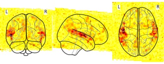
inter1_2: ISC test1 2.nii H1H2 t
- neurovault.org
Updated Oct 3, 2020+ more versionsShareFacebookTwitterEmailClick to copy linkLink copiedCite(2020). inter1_2: ISC test1 2.nii H1H2 t [Dataset]. http://identifiers.org/neurovault.image:407105Unique identifierhttps://identifiers.org/neurovault.image:407105Dataset updatedOct 3, 2020LicenseCC0 1.0 Universal Public Domain Dedicationhttps://creativecommons.org/publicdomain/zero/1.0/
License information was derived automaticallyDescriptionH1H2 t
Collection description
Subject species
homo sapiens
Map type
Other
Isc Gmbh Company profile with phone,email, buyers, suppliers, price, export...
- volza.com
csvUpdated Jun 30, 2025+ more versionsShareFacebookTwitterEmailClick to copy linkLink copiedCiteVolza FZ LLC (2025). Isc Gmbh Company profile with phone,email, buyers, suppliers, price, export import shipments. [Dataset]. https://www.volza.com/company-profile/isc-gmbh-31941802csvAvailable download formatsDataset updatedJun 30, 2025Dataset provided byVolzaAuthorsVolza FZ LLCLicenseAttribution 4.0 (CC BY 4.0)https://creativecommons.org/licenses/by/4.0/
License information was derived automaticallyTime period covered2014 - Sep 30, 2021Variables measuredCount of exporters, Count of importers, Sum of export value, Sum of import value, Count of export shipments, Count of import shipmentsDescriptionCredit report of Isc Gmbh contains unique and detailed export import market intelligence with it's phone, email, Linkedin and details of each import and export shipment like product, quantity, price, buyer, supplier names, country and date of shipment.
ZHAW-ISC 3D ToF and RGB Fusion Dataset
- zenodo.org
pngUpdated Oct 23, 2024ShareFacebookTwitterEmailClick to copy linkLink copiedCiteYannick Waelti; Yannick Waelti; Matthias Ludwig; Matthias Ludwig; Teddy Loeliger; Teddy Loeliger; Josquin Rosset; Josquin Rosset (2024). ZHAW-ISC 3D ToF and RGB Fusion Dataset [Dataset]. http://doi.org/10.5281/zenodo.10732158pngAvailable download formatsUnique identifierhttps://doi.org/10.5281/zenodo.10732158Dataset updatedOct 23, 2024AuthorsYannick Waelti; Yannick Waelti; Matthias Ludwig; Matthias Ludwig; Teddy Loeliger; Teddy Loeliger; Josquin Rosset; Josquin RossetLicenseAttribution 4.0 (CC BY 4.0)https://creativecommons.org/licenses/by/4.0/
License information was derived automaticallyTime period coveredMar 7, 2024DescriptionThis dataset contains depth maps recorded by an ESPROS epc635 Time-of-Flight camera and RGB images from a Raspberry Pi camera module V2, for use in the fusion of these sensors to increase the resolution of the ToF camera.
The dataset contains three scenes, one of a paper dodecahedron, a wooden grid with holes of various sizes, and a set of wooden bars with different distances between them. All scenes have a black background with low reflectivity at the 3D ToF camera’s illumination wavelength to reduce multi-path interference. An HDR image is created by combining two 3D ToF depth maps with different integration times based on the recorded amplitude of each pixel. The depth map is then transformed to the perspective of the RGB camera and the resulting holes are filled with the mean of their neighboring pixels.
The content of the included files are:
- Recorded HDR ToF camera depth maps (160x60), containing the depth values in millimeters, stored as 16-bit PNG files.
- Recorded RGB images (2560x960)
Global Yellow Isc buyers list and Global importers directory of Yellow Isc
- volza.com
csvUpdated Jun 30, 2025ShareFacebookTwitterEmailClick to copy linkLink copiedCiteVolza FZ LLC (2025). Global Yellow Isc buyers list and Global importers directory of Yellow Isc [Dataset]. https://www.volza.com/buyers-global/global-importers-buyers-of-yellow+isccsvAvailable download formatsDataset updatedJun 30, 2025Dataset provided byVolzaAuthorsVolza FZ LLCLicenseAttribution 4.0 (CC BY 4.0)https://creativecommons.org/licenses/by/4.0/
License information was derived automaticallyVariables measuredCount of exporters, Count of importers, Count of shipments, Sum of import value, 2014-01-01/2021-09-30Description10 Active Global Yellow Isc buyers list and Global Yellow Isc importers directory compiled from actual Global import shipments of Yellow Isc.
Isc Konstanz Ev Company profile with phone,email, buyers, suppliers, price,...
- volza.com
csvUpdated Jun 17, 2025ShareFacebookTwitterEmailClick to copy linkLink copiedCiteVolza FZ LLC (2025). Isc Konstanz Ev Company profile with phone,email, buyers, suppliers, price, export import shipments. [Dataset]. https://www.volza.com/company-profile/isc-konstanz-ev-18395290csvAvailable download formatsDataset updatedJun 17, 2025Dataset provided byVolzaAuthorsVolza FZ LLCLicenseAttribution 4.0 (CC BY 4.0)https://creativecommons.org/licenses/by/4.0/
License information was derived automaticallyTime period covered2014 - Sep 30, 2021Area coveredKonstanzVariables measuredCount of exporters, Count of importers, Sum of export value, Sum of import value, Count of export shipments, Count of import shipmentsDescriptionCredit report of Isc Konstanz Ev contains unique and detailed export import market intelligence with it's phone, email, Linkedin and details of each import and export shipment like product, quantity, price, buyer, supplier names, country and date of shipment.
Isc, Inc. Company profile with phone,email, buyers, suppliers, price, export...
- volza.com
csvUpdated Jul 14, 2025+ more versionsShareFacebookTwitterEmailClick to copy linkLink copiedCiteVolza FZ LLC (2025). Isc, Inc. Company profile with phone,email, buyers, suppliers, price, export import shipments. [Dataset]. https://www.volza.com/company-profile/isc-inc-international-scientific-consultants-inc-32043220csvAvailable download formatsDataset updatedJul 14, 2025Dataset provided byVolzaAuthorsVolza FZ LLCLicenseAttribution 4.0 (CC BY 4.0)https://creativecommons.org/licenses/by/4.0/
License information was derived automaticallyTime period covered2014 - Sep 30, 2021Variables measuredCount of exporters, Count of importers, Sum of export value, Sum of import value, Count of export shipments, Count of import shipmentsDescriptionCredit report of Isc, Inc. contains unique and detailed export import market intelligence with it's phone, email, Linkedin and details of each import and export shipment like product, quantity, price, buyer, supplier names, country and date of shipment.
Isc Elevator Products Company profile with phone,email, buyers, suppliers,...
- volza.com
csvUpdated Jan 7, 2025ShareFacebookTwitterEmailClick to copy linkLink copiedCiteVolza FZ LLC (2025). Isc Elevator Products Company profile with phone,email, buyers, suppliers, price, export import shipments. [Dataset]. https://www.volza.com/company-profile/isc-elevator-products-43673132csvAvailable download formatsDataset updatedJan 7, 2025Dataset provided byVolzaAuthorsVolza FZ LLCLicenseAttribution 4.0 (CC BY 4.0)https://creativecommons.org/licenses/by/4.0/
License information was derived automaticallyTime period covered2014 - Sep 30, 2021Variables measuredCount of exporters, Count of importers, Sum of export value, Sum of import value, Count of export shipments, Count of import shipmentsDescriptionCredit report of Isc Elevator Products contains unique and detailed export import market intelligence with it's phone, email, Linkedin and details of each import and export shipment like product, quantity, price, buyer, supplier names, country and date of shipment.
- f
Peak voxel coordinates (x, y, and z in MNI system) and anatomical labels for...
- plos.figshare.com
- figshare.com
xlsUpdated May 30, 2023ShareFacebookTwitterEmailClick to copy linkLink copiedCiteRobert Boldt; Sanna Malinen; Mika Seppä; Pia Tikka; Petri Savolainen; Riitta Hari; Synnöve Carlson (2023). Peak voxel coordinates (x, y, and z in MNI system) and anatomical labels for the ISC map. [Dataset]. http://doi.org/10.1371/journal.pone.0064489.t001xlsAvailable download formatsUnique identifierhttps://doi.org/10.1371/journal.pone.0064489.t001Dataset updatedMay 30, 2023Dataset provided byPLOS ONEAuthorsRobert Boldt; Sanna Malinen; Mika Seppä; Pia Tikka; Petri Savolainen; Riitta Hari; Synnöve CarlsonLicenseAttribution 4.0 (CC BY 4.0)https://creativecommons.org/licenses/by/4.0/
License information was derived automaticallyDescription* = rostral/anterior part.† = posterior part.N refers to the number of voxels in each cluster. Anatomical labeling is based on the group data, and was performed with the Automated Anatomical Labeling (AAL) tool. Labels are listed if an ISC map cluster extended ≥10 voxels into the AAL defined area.
Global exporters importers-export import data of Yellow isc
- volza.com
csvUpdated Jan 7, 2025ShareFacebookTwitterEmailClick to copy linkLink copiedCiteVolza FZ LLC (2025). Global exporters importers-export import data of Yellow isc [Dataset]. https://www.volza.com/p/yellow-isc/csvAvailable download formatsDataset updatedJan 7, 2025Dataset provided byVolzaAuthorsVolza FZ LLCLicenseAttribution 4.0 (CC BY 4.0)https://creativecommons.org/licenses/by/4.0/
License information was derived automaticallyVariables measuredCount of exporters, Count of importers, Count of shipments, Sum of export import valueDescription48 Global exporters importers export import shipment records of Yellow isc with prices, volume & current Buyer's suppliers relationships based on actual Global export trade database.
- r
2010 Index of Stream Condition - Large Trees 100m Section Summary Table
- researchdata.edu.au
Updated Sep 26, 2023+ more versionsShareFacebookTwitterEmailClick to copy linkLink copiedCitedata.vic.gov.au (2023). 2010 Index of Stream Condition - Large Trees 100m Section Summary Table [Dataset]. https://researchdata.edu.au/2010-index-stream-summary-table/2824662Dataset updatedSep 26, 2023Dataset provided bydata.vic.gov.auLicenseAttribution 4.0 (CC BY 4.0)https://creativecommons.org/licenses/by/4.0/
License information was derived automaticallyDescriptionThe ISC2010_LARGE_TREES_S table is the Statistical Summary table for the Large Trees Metric at the 100m Section level.
The ISC2010_LARGE_TREES_S table is designed to JOIN to the ISC2010_RIVER_CENTRELINES_S feature class.
River condition in Victoria is assessed every 5 years using the Index of Stream Condition (ISC). The Department of Environment and Primary Industries (DEPI) developed a methodology to assess the Physical Form and Riparian Vegetation components of the ISC using remote sensing data, specifically LIDAR and aerial photography.
A State Wide mapping project was undertaken in 2010-13 to accurately map the Physical Form and Riparian Vegetation metrics of the ISC . Other ISC metrics were not assessed in the project and were derived from other sources.
The Physical Form and Riparian Vegetation Metric products are a combination of mapped Vector and Raster data as well as Tabular Summary Statistics about the mapped features. In the context of the project, the term Metrics is used to refer to both the mapped features and the summary statistics.
Remote sensing data used includes 15cm true colour and infra-red aerial photography and four return multi-pulse LiDAR data. This source data was used to derive a variety of Raster data sets including Digital Terrain Models, Slope, Vegetation Height and Vegetation Cover. The Digital Terrain and Slope rasters were used to map Physical Form metrics including Stream Bed, Top of Bank and River Centre Lines while the Vegetation Height and Cover rasters were used to map the Riparian Vegetation metrics. The Project Report "Aerial Remote Sensing for Physical Channel Form and Riparian Vegetation Mapping" describes the remote sensing and mapping approach used to create this data set.
FacebookTwitterOpen Data Commons Attribution License (ODC-By) v1.0https://www.opendatacommons.org/licenses/by/1.0/
License information was derived automatically
OSE/ISC maintains a network of stream, acequia, ditch and well monitoring sites that electronically transmits data values via radio and satellite telemetry and stores the data in a database. This real-time water measurement data is available for each active gage/well shown on select basin maps.