OpenStreetMap
- data.baltimorecity.gov
- bbmaps.mapcram.com
- +46more
Updated Mar 19, 2019+ more versions Share
Share Facebook
 Twitter
 EmailClick to copy linkLink copiedCiteesri_en (2019). OpenStreetMap [Dataset]. https://data.baltimorecity.gov/maps/c29cfb7875fc4b97b58ba6987c460862Dataset updatedMar 19, 2019Authorsesri_enArea coveredDescription
This web map presents a vector basemap of OpenStreetMap (OSM) data hosted by Esri. Esri created this vector tile basemap from the Daylight map distribution of OSM data, which is supported by Facebook and supplemented with additional data from Microsoft. This version of the map is rendered using OSM cartography. The OSM Daylight map will be updated every month with the latest version of OSM Daylight data.OpenStreetMap is an open collaborative project to create a free editable map of the world. Volunteers gather location data using GPS, local knowledge, and other free sources of information and upload it. The resulting free map can be viewed and downloaded from the OpenStreetMap site:www.OpenStreetMap.org. Esri is a supporter of the OSM project and is excited to make this enhanced vector basemap available to the ArcGIS user and developer communities.
OpenStreetMap (Blueprint)
- catalog.data.gov
- data.baltimorecity.gov
- +15more
Updated Jun 8, 2024+ more versionsShareFacebookTwitterEmailClick to copy linkLink copiedCiteEsri (2024). OpenStreetMap (Blueprint) [Dataset]. https://catalog.data.gov/dataset/openstreetmap-blueprint-653c6Dataset updatedJun 8, 2024DescriptionThis web map features a vector basemap of OpenStreetMap (OSM) data created and hosted by Esri. Esri produced this vector tile basemap in ArcGIS Pro from a live replica of OSM data, hosted by Esri, and rendered using a creative cartographic style emulating a blueprint technical drawing. The vector tiles are updated every few weeks with the latest OSM data. This vector basemap is freely available for any user or developer to build into their web map or web mapping apps.OpenStreetMap (OSM) is an open collaborative project to create a free editable map of the world. Volunteers gather location data using GPS, local knowledge, and other free sources of information and upload it. The resulting free map can be viewed and downloaded from the OpenStreetMap site: www.OpenStreetMap.org. Esri is a supporter of the OSM project and is excited to make this new vector basemap available available to the OSM, GIS, and Developer communities.
OpenStreetMap (Streets Night)
- cacgeoportal.com
- hub.arcgis.com
- +1more
Updated Jun 13, 2023+ more versionsShareFacebookTwitterEmailClick to copy linkLink copiedCiteEsri (2023). OpenStreetMap (Streets Night) [Dataset]. https://www.cacgeoportal.com/maps/13669d69469e43bb9567ec63812e3b33Dataset updatedJun 13, 2023Area coveredPacific Ocean, South Pacific OceanDescriptionImportant Note: This item is in mature support as of December 2024. See blog for more information.This web map presents a vector basemap of OpenStreetMap (OSM) data hosted by Esri. This version of the map is rendered in a style similar to the Night version of the Esri Street map. The GCS vector tiles are updated quarterly. Created from the sunsetted Daylight map distribution, data updates supporting this layer are no longer available.OpenStreetMap is an open collaborative project to create a free editable map of the world. Volunteers gather location data using GPS, local knowledge, and other free sources of information and upload it. The resulting free map can be viewed and downloaded from the OpenStreetMap site: www.OpenStreetMap.org. Esri is a supporter of the OSM project.
OpenStreetMap Navigation Dark
- cacgeoportal.com
- keep-cool-global-community.hub.arcgis.com
- +1more
Updated Jun 9, 2022ShareFacebookTwitterEmailClick to copy linkLink copiedCiteEsri (2022). OpenStreetMap Navigation Dark [Dataset]. https://www.cacgeoportal.com/maps/92966c7ebc3d4ddaac34050560568badDataset updatedJun 9, 2022Area coveredPacific Ocean, South Pacific OceanDescriptionImportant Note: This item is in mature support as of December 2024. See blog for more information.This tile layer presents a vector basemap of OpenStreetMap (OSM) data hosted by Esri. This version of the map is rendered in a style similar to the Esri Navigation Dark Mode map. Created from the sunsetted Daylight map distribution, data updates supporting this layer are no longer available.OpenStreetMap is an open collaborative project to create a free editable map of the world. Volunteers gather location data using GPS, local knowledge, and other free sources of information and upload it. The resulting free map can be viewed and downloaded from the OpenStreetMap site: www.OpenStreetMap.org. Esri is a supporter of the OSM project.
OpenStreetMap (Navigation - WGS84)
- cacgeoportal.com
- hub.arcgis.com
- +1more
Updated May 24, 2022+ more versionsShareFacebookTwitterEmailClick to copy linkLink copiedCiteEsri (2022). OpenStreetMap (Navigation - WGS84) [Dataset]. https://www.cacgeoportal.com/maps/ff1bc11d072d4dc3ac6dd675432e21d1Dataset updatedMay 24, 2022Area coveredOceania, Pacific Ocean, North Pacific OceanDescriptionImportant Note: This item is in mature support as of December 2024. See blog for more information.This web map presents a vector basemap of OpenStreetMap (OSM) data hosted by Esri. This version of the map is rendered in a style similar to the Esri Navigation map. Created from the sunsetted Daylight map distribution, data updates supporting this layer are no longer available.OpenStreetMap is an open collaborative project to create a free editable map of the world. Volunteers gather location data using GPS, local knowledge, and other free sources of information and upload it. The resulting free map can be viewed and downloaded from the OpenStreetMap site: www.OpenStreetMap.org. Esri is a supporter of the OSM project. Precise Tile Registration: The web map uses the improved tiling scheme “WGS84 Geographic, Version 2” to ensure proper tile positioning at higher resolutions (neighborhood level and beyond). The new tiling scheme is much more precise than tiling schemes of the legacy basemaps Esri released years ago. We recommend that you start using this new basemap for any new web maps in WGS84 that you plan to author. Due to the number of differences between the old and new tiling schemes, some web clients will not be able to overlay tile layers in the old and new tiling schemes in one web map.
- c
OpenStreetMap Caribbean
- caribbeangeoportal.com
- data.amerigeoss.org
Updated Mar 19, 2020ShareFacebookTwitterEmailClick to copy linkLink copiedCiteCaribbean GeoPortal (2020). OpenStreetMap Caribbean [Dataset]. https://www.caribbeangeoportal.com/maps/5889f432a73e49c29f653569434344aaDataset updatedMar 19, 2020Dataset authored and provided byCaribbean GeoPortalLicenseAttribution 4.0 (CC BY 4.0)https://creativecommons.org/licenses/by/4.0/
License information was derived automaticallyArea coveredDescriptionThis map references the OpenStreetMap tile layer hosted by Esri. This tile layer presents a new vector basemap of OpenStreetMap (OSM) data created and hosted by Esri, now in beta release. Esri produced this vector tile basemap in ArcGIS Pro from a live replica of OSM data, hosted by Esri, that was rendered using OSM cartography. The vector tiles are updated every few weeks; refer to the OpenStreetMap tile layer for details on when it was last updated. When fully released, this vector basemap will be freely available for any user or developer to build into their web map or web mapping apps.OpenStreetMap (OSM) is an open collaborative project to create a free editable map of the world. Volunteers gather location data using GPS, local knowledge, and other free sources of information and upload it. The resulting free map can be viewed and downloaded from the OpenStreetMap site: www.OpenStreetMap.org. Esri is a supporter of the OSM project and is excited to make this new vector basemap available available to the OSM, GIS, and Developer communities.
- N
Data from: Individual Brain Charting dataset extension, second release of...
- neurovault.org
zipUpdated Oct 26, 2020+ more versionsShareFacebookTwitterEmailClick to copy linkLink copiedCite(2020). Individual Brain Charting dataset extension, second release of high-resolution fMRI data for cognitive mapping [Dataset]. http://identifiers.org/neurovault.collection:6618zipAvailable download formatsUnique identifierhttps://identifiers.org/neurovault.collection:6618Dataset updatedOct 26, 2020LicenseCC0 1.0 Universal Public Domain Dedicationhttps://creativecommons.org/publicdomain/zero/1.0/
License information was derived automaticallyDescriptionA collection of 9532 brain maps. Each brain map is a 3D array of values representing properties of the brain at different locations.
Collection description
The individual Brain Charting (IBC) Project is using high resolution fMRI to map 13 subjects that undergo a large number of tasks: the HCP tasks, the so-called ARCHI tasks, a specific language task, video watching, low-level visual stimulation etc. The native resolution of the data is 1.5mm isotropic. Their main value lies in the large number of contrasts probed, the level of detail and the high SNR per subject. This dataset is meant to provide the basis of a functional brain atlas. We upload here smoothed individual SPMs. The uploaded maps comprise session-specific and fixed effects across maps acquired with AP and PA phase encoding directions.
Note that Neurovault collection #4438 is a subset of that one. In the present collections, some details have been fixed, including mroe accurate and unique file naming.
- a
CMMPO Culvert Locations Map
- hub.arcgis.com
- gis.data.mass.gov
Updated Aug 1, 2021+ more versionsShareFacebookTwitterEmailClick to copy linkLink copiedCiteCMRPC (2021). CMMPO Culvert Locations Map [Dataset]. https://hub.arcgis.com/maps/dec273a1a54b4f0c96871ec7a03434a5Dataset updatedAug 1, 2021Dataset authored and provided byCMRPCArea coveredDescriptionAboutThis is a map displaying all North Atlantic Aquatic Connectivity Collaborative (NAACC) non-tidal culvert assessments in the Central Massachusetts Municipal Planning Organization (CMMPO) region. The culvert data was last updated in February, 2025. The culverts dataset is updated periodically from the NAACC Data Center, in which culvert assessment data is uploaded as it is collected. The culvert dataset was last updated on February 12, 2025. The map was last updated on March 17, 2025. Culvert DataThe dataset is updated periodically from the NAACC Data Center, in which culvert assessment data is uploaded as it is collected in the field. On the map, the layer displays the barrier condition of each culvert. These barriers and their symbology color include:Severe - RedSignificant - OrangeModerate - YellowMinor - BlueInsignificant - Light BlueNo Barrier - GreenNo Score/Missing Data - PinkNot Assessed - Dark GrayBy clicking the culverts (points) on the map, more data is available for each structure, like when it was assessed/last updated, it's crossing code, it's aquatic organism passage (AOP) score, and more. Data Source: North Atlantic Aquatic Connectivity Collaborative (NAACC)Download Culvert Data: NAACC Data CenterArcGIS Online Data Layer Source: Culverts in MassachusettsIcon source: https://www.flaticon.com/authors/itim2101
OpenStreetMap (Streets with Relief - WGS84)
- hub.arcgis.com
- cacgeoportal.com
- +4more
Updated Sep 5, 2019+ more versionsShareFacebookTwitterEmailClick to copy linkLink copiedCiteEsri (2019). OpenStreetMap (Streets with Relief - WGS84) [Dataset]. https://hub.arcgis.com/maps/8978501dcd724175be8913ed87166b2fDataset updatedSep 5, 2019Area coveredDescriptionImportant Note: This item is in mature support as of December 2024. See blog for more information.This web map presents a vector basemap of OpenStreetMap (OSM) data hosted by Esri. This version of the map is rendered in a style similar to the Esri Street Map (with Relief). It includes the World Hillshade layer. Created from the sunsetted Daylight map distribution, data updates supporting this layer are no longer available.OpenStreetMap is an open collaborative project to create a free editable map of the world. Volunteers gather location data using GPS, local knowledge, and other free sources of information and upload it. The resulting free map can be viewed and downloaded from the OpenStreetMap site: www.OpenStreetMap.org. Esri is a supporter of the OSM project. Precise Tile Registration: The web map uses the improved tiling scheme “WGS84 Geographic, Version 2” to ensure proper tile positioning at higher resolutions (neighborhood level and beyond). The new tiling scheme is much more precise than tiling schemes of the legacy basemaps Esri released years ago. We recommend that you start using this new basemap for any new web maps in WGS84 that you plan to author. Due to the number of differences between the old and new tiling schemes, some web clients will not be able to overlay tile layers in the old and new tiling schemes in one web map.
OpenStreetMap 3D Buildings
- geoportal-pacificcore.hub.arcgis.com
- uneca.africageoportal.com
- +7more
Updated Jun 3, 2022+ more versionsShareFacebookTwitterEmailClick to copy linkLink copiedCiteEsri (2022). OpenStreetMap 3D Buildings [Dataset]. https://geoportal-pacificcore.hub.arcgis.com/maps/ca0470dbbddb4db28bad74ed39949e25Dataset updatedJun 3, 2022Area coveredSouth Pacific Ocean, Pacific OceanDescriptionImportant Note: This item is in mature support as of December 2024. See blog for more information.This 3D scene layer presents OpenStreetMap (OSM) buildings data hosted by Esri. Esri created buildings and trees scene layers from the OSM Daylight map distribution, which is supported by Facebook and others. The Daylight map distribution has been sunsetted and data updates supporting this layer are no longer available. You can visit openstreetmap.maps.arcgis.com to explore a collection of maps, scenes, and layers featuring OpenStreetMap data in ArcGIS. You can review the 3D Scene Layers Documentation to learn more about how the building and tree features in OSM are modeled and rendered in the 3D scene layers, and see tagging recommendations to get the best results.OpenStreetMap is an open collaborative project to create a free editable map of the world. Volunteers gather location data using GPS, local knowledge, and other free sources of information and upload it. The resulting free map can be viewed and downloaded from the OpenStreetMap site: www.OpenStreetMap.org. Esri is a supporter of the OSM project.Note: This layer is supported in Scene Viewer and ArcGIS Pro 3.0 or higher.
OpenStreetMap Hybrid Reference (WGS84)
- keep-cool-global-community.hub.arcgis.com
- cacgeoportal.com
- +1more
Updated Jun 18, 2019+ more versionsShareFacebookTwitterEmailClick to copy linkLink copiedCiteEsri (2019). OpenStreetMap Hybrid Reference (WGS84) [Dataset]. https://keep-cool-global-community.hub.arcgis.com/maps/e67de4be72b349fd8f8ca114bac82a8cDataset updatedJun 18, 2019DescriptionImportant Note: This item is in mature support as of December 2024. See blog for more information.This tile layer presents a vector basemap of OpenStreetMap (OSM) data hosted by Esri. It provides a reference layer featuring map labels, boundary lines, and roads. This layer is designed to be overlaid on imagery. Created from the sunsetted Daylight map distribution, data updates supporting this layer are no longer available.OpenStreetMap is an open collaborative project to create a free editable map of the world. Volunteers gather location data using GPS, local knowledge, and other free sources of information and upload it. The resulting free map can be viewed and downloaded from the OpenStreetMap site: www.OpenStreetMap.org. Esri is a supporter of the OSM project.Precise Tile Registration: The tile layer uses the improved tiling scheme “WGS84 Geographic, Version 2” to ensure proper tile positioning at higher resolutions (neighborhood level and beyond). The new tiling scheme is much more precise than tiling schemes of the legacy basemaps Esri released years ago. We recommend that you start using this new basemap for any new web maps in WGS84 that you plan to author. Due to the number of differences between the old and new tiling schemes, some web clients will not be able to overlay tile layers in the old and new tiling schemes in one web map.
- A
College Map
- data.amerigeoss.org
- catalog.data.gov
- +1more
Updated Feb 18, 2022+ more versionsShareFacebookTwitterEmailClick to copy linkLink copiedCiteUnited States (2022). College Map [Dataset]. https://data.amerigeoss.org/dataset/college-map-b0edcarcgis geoservices rest api, htmlAvailable download formatsDataset updatedFeb 18, 2022Dataset provided byUnited StatesLicenseU.S. Government Workshttps://www.usa.gov/government-works
License information was derived automaticallyDescriptionFinding Schools is now easier than ever with the College Map, the first geographic search tool published by IPEDS (Integrated Postsecondary Education Data System) providing access to over 7,000 certificate, undergraduate and graduate-level schools. This all-in-one tool enables students, parents and counselors to filter potential programs for location, major, tuition and more. Including both certificate-level programs and advanced degrees, this public application makes the often overwhelming process of school searching simple, and it’s available on mobile devices.
Once the results are narrowed down, users can share their lists on social media or download in excel format. Additionally, the College Map integrates with the College Navigator, a research based search tool providing data from the complete list of IPEDS Survey indicators.
All information contained in this file is in the public domain. Data users are advised to review NCES program documentation and feature class metadata to understand the limitations and appropriate use of these data.
OpenStreetMap Dark Gray Canvas
- hub.arcgis.com
- keep-cool-global-community.hub.arcgis.com
- +1more
Updated Oct 20, 2020+ more versionsShareFacebookTwitterEmailClick to copy linkLink copiedCiteEsri (2020). OpenStreetMap Dark Gray Canvas [Dataset]. https://hub.arcgis.com/maps/a9a842b3eec14a60a913ed718d19b957Dataset updatedOct 20, 2020Area coveredPacific Ocean, South Pacific OceanDescriptionImportant Note: This item is in mature support as of December 2024. See blog for more information.This tile layer presents a vector basemap of OpenStreetMap (OSM) data hosted by Esri. This version of the map is rendered in a dark neutral style with minimal colors. Created from the sunsetted Daylight map distribution, data updates supporting this layer are no longer available.OpenStreetMap is an open collaborative project to create a free editable map of the world. Volunteers gather location data using GPS, local knowledge, and other free sources of information and upload it. The resulting free map can be viewed and downloaded from the OpenStreetMap site: www.OpenStreetMap.org. Esri is a supporter of the OSM project.
- H
Public GIS files for mapping carbonate springs
- hydroshare.org
- beta.hydroshare.org
- +1more
zipUpdated Aug 19, 2024ShareFacebookTwitterEmailClick to copy linkLink copiedCiteLaura Toran; Michael Jones (2024). Public GIS files for mapping carbonate springs [Dataset]. https://www.hydroshare.org/resource/07ebf29817dc423aae09de01741c167ezip(5.1 MB)Available download formatsDataset updatedAug 19, 2024Dataset provided byHydroShareAuthorsLaura Toran; Michael JonesLicenseAttribution 4.0 (CC BY 4.0)https://creativecommons.org/licenses/by/4.0/
License information was derived automaticallyArea coveredDescriptionThis abstract contains links to public ArcGIS maps that include locations of carbonate springs and some of their characteristics. Information for accessing and navigating through the maps are included in a PowerPoint presentation IN THE FILE UPLOAD SECTION BELOW. Three separate data sets are included in the maps:
- Geochemistry data from the US Water Quality Portal (WQP), which compiles geochemistry data from the USGS and other federal agencies.
- Discharge data from WoKaS, a world wide spring discharge data set (Olarinoye et al., 2020).
- Regional karst data from selected US state agencies.
Several base maps are included in the links. The US carbonate map describes and categorizes carbonates (e.g., depth from surface, overlying geology/ice, climate). The carbonate springs map categorizes springs as being urban, specifically within 1000 ft of a road, or rural. The basis for this categorization was that the heat island effect defines urban as within a 1000 ft of a road. There are other methods for defining urban versus rural to consider. Map links and details of the information they contain are listed below.
Map set 1: The WQP map provides three mapping options separated by the parameters available at each spring site. These maps summarize discrete water quality samples, but not data logger availability. Information at each spring provides links for where users can explore further data.
Option 1: WQP data with urban and rural springs labeled, with highlight of springs with or without NWIS data https://www.arcgis.com/home/item.html?id=2ce914ec01f14c20b58146f5d9702d8a
Options 2: WQP data by major ions and a few other solutes https://www.arcgis.com/home/item.html?id=5a114d2ce24c473ca07ef9625cd834b8
Option 3:WQP data by various carbon species https://www.arcgis.com/home/item.html?id=ae406f1bdcd14f78881905c5e0915b96
Map 2: The worldwide carbonate map in the WoKaS data set (citation below) includes a description of carbonate purity and distribution of urban and rural springs, for which discharge data are available: https://www.arcgis.com/apps/mapviewer/index.html?webmap=5ab43fdb2b784acf8bef85b61d0ebcbe.
Reference: Olarinoye, T., Gleeson, T., Marx, V., Seeger, S., Adinehvand, R., Allocca, V., Andreo, B., Apaéstegui, J., Apolit, C., Arfib, B. and Auler, A., 2020. Global karst springs hydrograph dataset for research and management of the world’s fastest-flowing groundwater. Scientific Data, 7(1), pp.1-9.
Map 3: Karst and spring data from selected states: This map includes sites that members of the RCN have suggested to our group.
https://uageos.maps.arcgis.com/apps/mapviewer/index.html?webmap=28ed22a14bb749e2b22ece82bf8a8177
This data set is incomplete (as of October 13, 2022 it includes Florida and Missouri). We are looking for more information. You can share data links to additional data by typing them into the hydroshare page created for our group. Then new sites will periodically be added to the map: https://www.hydroshare.org/resource/0cf10e9808fa4c5b9e6a7852323e6b11/
Acknowledgements: These maps were created by Michael Jones, University of Arkansas and Shishir Sarker, University of Kentucky with help from Laura Toran and Francesco Navarro, Temple University.
TIPS FOR NAVIGATING THE MAPS ARE IN THE POWERPOINT DOCUMENT IN THE FILE UPLOAD SECTION BELOW.
- N
Individual Brain Charting dataset extension, second release of...
- neurovault.org
niftiUpdated Feb 14, 2020+ more versionsShareFacebookTwitterEmailClick to copy linkLink copiedCite(2020). Individual Brain Charting dataset extension, second release of high-resolution fMRI data for cognitive mapping: sub-07_ses-16_task-pain_movie_dir-ap_movie_mental [Dataset]. http://identifiers.org/neurovault.image:362118niftiAvailable download formatsUnique identifierhttps://identifiers.org/neurovault.image:362118Dataset updatedFeb 14, 2020LicenseCC0 1.0 Universal Public Domain Dedicationhttps://creativecommons.org/publicdomain/zero/1.0/
License information was derived automaticallyDescription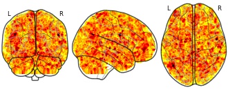
Collection description
The individual Brain Charting (IBC) Project is using high resolution fMRI to map 13 subjects that undergo a large number of tasks: the HCP tasks, the so-called ARCHI tasks, a specific language task, video watching, low-level visual stimulation etc. The native resolution of the data is 1.5mm isotropic. Their main value lies in the large number of contrasts probed, the level of detail and the high SNR per subject. This dataset is meant to provide the basis of a functional brain atlas. We upload here smoothed individual SPMs. The uploaded maps comprise session-specific and fixed effects across maps acquired with AP and PA phase encoding directions.
Note that Neurovault collection #4438 is a subset of that one. In the present collections, some details have been fixed, including mroe accurate and unique file naming.
Subject species
homo sapiens
Modality
fMRI-BOLD
Analysis level
single-subject
Cognitive paradigm (task)
Pain-matrix narrative localizer
Map type
Z
- N
Individual Brain Charting dataset extension, second release of...
- neurovault.org
niftiUpdated Feb 14, 2020+ more versionsShareFacebookTwitterEmailClick to copy linkLink copiedCite(2020). Individual Brain Charting dataset extension, second release of high-resolution fMRI data for cognitive mapping: sub-05_ses-12_task-mtt_sn_dir-ap_run-03_sn_southside_event [Dataset]. http://identifiers.org/neurovault.image:361510niftiAvailable download formatsUnique identifierhttps://identifiers.org/neurovault.image:361510Dataset updatedFeb 14, 2020LicenseCC0 1.0 Universal Public Domain Dedicationhttps://creativecommons.org/publicdomain/zero/1.0/
License information was derived automaticallyDescription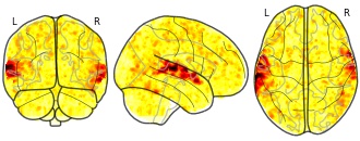
Collection description
The individual Brain Charting (IBC) Project is using high resolution fMRI to map 13 subjects that undergo a large number of tasks: the HCP tasks, the so-called ARCHI tasks, a specific language task, video watching, low-level visual stimulation etc. The native resolution of the data is 1.5mm isotropic. Their main value lies in the large number of contrasts probed, the level of detail and the high SNR per subject. This dataset is meant to provide the basis of a functional brain atlas. We upload here smoothed individual SPMs. The uploaded maps comprise session-specific and fixed effects across maps acquired with AP and PA phase encoding directions.
Note that Neurovault collection #4438 is a subset of that one. In the present collections, some details have been fixed, including mroe accurate and unique file naming.
Subject species
homo sapiens
Modality
fMRI-BOLD
Analysis level
single-subject
Cognitive paradigm (task)
Mental time travel task
Map type
Z
OpenStreetMap (Topographic)
- cacgeoportal.com
- hub.arcgis.com
Updated Mar 7, 2023ShareFacebookTwitterEmailClick to copy linkLink copiedCiteEsri (2023). OpenStreetMap (Topographic) [Dataset]. https://www.cacgeoportal.com/maps/3b484bf1b7cf4e33beaca992bdfc3c2fDataset updatedMar 7, 2023Area coveredPacific Ocean, South Pacific OceanDescriptionImportant Note: This beta item will retire in December 2025 and is no longer recommended for use.This web map presents a vector basemap of OpenStreetMap (OSM) data hosted by Esri. Esri created this vector tile basemap from the Daylight map distribution of OSM data, which is supported by Facebook and supplemented with additional data from Microsoft. This version of the map is rendered in a style similar to the Esri Topographic map. It includes vector contours and hillshade in the multi-source tile layer. OpenStreetMap (OSM) is an open collaborative project to create a free editable map of the world. Volunteers gather location data using GPS, local knowledge, and other free sources of information and upload it. The resulting free map can be viewed and downloaded from the OpenStreetMap site: www.OpenStreetMap.org. Esri is a supporter of the OSM project.
OpenStreetMap Vector Basemap
- cacgeoportal.com
- keep-cool-global-community.hub.arcgis.com
- +3more
Updated Jul 4, 2018ShareFacebookTwitterEmailClick to copy linkLink copiedCiteEsri (2018). OpenStreetMap Vector Basemap [Dataset]. https://www.cacgeoportal.com/datasets/esri::openstreetmap-vector-basemap-1Dataset updatedJul 4, 2018DescriptionImportant Note: This item is in mature support as of December 2024. See blog for more information.This app features a vector basemap of OpenStreetMap (OSM) data hosted by Esri. Esri created this vector tile basemap from the Daylight map distribution of OSM data, which is supported by Facebook and supplemented with additional data from Microsoft. This version of the map is rendered using OSM cartography. The OSM Daylight map will be updated every month with the latest version of OSM Daylight data. OpenStreetMap is an open collaborative project to create a free editable map of the world. Volunteers gather location data using GPS, local knowledge, and other free sources of information and upload it. The resulting free map can be viewed and downloaded from the OpenStreetMap site: www.OpenStreetMap.org. Esri is a supporter of the OSM project and is excited to make this enhanced vector basemap available to the ArcGIS user and developer communities.
- c
Broadband Data by Tract - 2023
- geodata.ct.gov
- data.ct.gov
- +4more
Updated Nov 25, 2023+ more versionsShareFacebookTwitterEmailClick to copy linkLink copiedCiteState of Connecticut (2023). Broadband Data by Tract - 2023 [Dataset]. https://geodata.ct.gov/datasets/ctmaps::broadband-data-by-tract-2023Dataset updatedNov 25, 2023Dataset authored and provided byState of ConnecticutLicenseCC0 1.0 Universal Public Domain Dedicationhttps://creativecommons.org/publicdomain/zero/1.0/
License information was derived automaticallyArea coveredDescriptionThis feature layer provides all OPM collected data at the tract level.------The Connecticut Broadband Availability and Adoption Maps were created to help citizens and policymakers understand the strengths and weaknesses of broadband infrastructure in the state. Data is aggregated to the block, tract, and town (county subdivision) levels and includes counts of locations classified as unserved, underserved, and served as well as whether they meet the state goal of 1000Mbps/100Mbps. This application splits its visualizations into block, tract, and town layers for both unserved locations and progress to the state goal.
This map uses OPM collected availability and adoption data.
As of 2023, OPM collected availability data was submitted by internet service providers pursuant to PA 21-159 and processed by the GIS Office in the Office of Policy and Management, cleaned, and matched to the CostQuest location fabric.
Metadata:
All feature layers, maps, and datasets including OPM's internal broadband availability data follows the same basic schema with additional fields added in some case for convenience.
Fields named no service, unserved, underserved, served, and GigC are counts of locations where a particular level of broadband service is provided, No service locations are those where there is no reported service at all. Unserved locations are locations where there is a provider offering wireline service, but not at or above 25 Mbps download and 3 Mbps upload. Underserved locations are locations where at least one provider offers wireline service of 25 Mbps download and 3 Mbps upload, but there is no provider offering wireline service of 100 Mbps download and 20 Mbps upload. Served locations are locations where there is wireline service of at least 100 Mbps download and 20 Mbps upload. GigC denotes the count of locations that have service at 1000 Mbps download and 100 Mbps upload. Accordingly, total locations is equal to the sum of no service, unserved, underserved, served, and "GigC" locations. Availability also includes fields for average download and upload speeds. These are calculated at the relevant level of census geography based on the maximum for all locations.
The final field included in all availability data is the provider list.
OPM collected adoption data:
OPM collected adoption data uses many of the same naming conventions as the availability data, but there are some notable differences.
Fields named unserved_Sub, underserved_Sub, served_Sub, and GigC _Sub are counts of subscriptions where a particular level of broadband service is currently subscribed to, Unserved subscriptions are subscriptions that do not meet the standard of 25 Mbps download and 3 Mbps upload. Underserved subscriptions are subscriptions with speeds of 25 Mbps download and 3 Mbps upload, but not meeting 100 Mbps download and 20 Mbps upload. Served subscriptions are subscriptions where speeds are between 100 Mbps download and 20 Mbps upload and 1000 Mbps download and 100 Mbps upload. GigC denotes the count of locations that have a subscription at 1000 Mbps download and 100 Mbps upload or higher. For subscription data these locations are NOT included in the "served" field as this does not directly apply to FCC use of the terms.
OpenStreetMap (Dark Gray Canvas - WGS84)
- hub.arcgis.com
- keep-cool-global-community.hub.arcgis.com
- +1more
Updated Apr 13, 2020+ more versionsShareFacebookTwitterEmailClick to copy linkLink copiedCiteEsri (2020). OpenStreetMap (Dark Gray Canvas - WGS84) [Dataset]. https://hub.arcgis.com/maps/e4415edaa22b458681145f2754df331aDataset updatedApr 13, 2020Area coveredPacific Ocean, North Pacific OceanDescriptionImportant Note: This item is in mature support as of December 2024. See blog for more information.This web map presents a vector basemap of OpenStreetMap (OSM) data hosted by Esri. It provides a detailed base layer for the world featuring a dark neutral style with minimal colors, OpenStreetMap Dark Gray Canvas Base (WGS84) and also an overlaying reference layer, OpenStreetMap Dark Gray Canvas Reference (WGS84). Created from the sunsetted Daylight map distribution, data updates supporting this layer are no longer available.OpenStreetMap is an open collaborative project to create a free editable map of the world. Volunteers gather location data using GPS, local knowledge, and other free sources of information and upload it. The resulting free map can be viewed and downloaded from the OpenStreetMap site: www.OpenStreetMap.org. Esri is a supporter of the OSM project. Precise Tile Registration: The tile layer uses the improved tiling scheme “WGS84 Geographic, Version 2” to ensure proper tile positioning at higher resolutions (neighborhood level and beyond). The new tiling scheme is much more precise than tiling schemes of the legacy basemaps Esri released years ago. We recommend that you start using this new basemap for any new web maps in WGS84 that you plan to author. Due to the number of differences between the old and new tiling schemes, some web clients will not be able to overlay tile layers in the old and new tiling schemes in one web map.
FacebookTwitterThis web map presents a vector basemap of OpenStreetMap (OSM) data hosted by Esri. Esri created this vector tile basemap from the Daylight map distribution of OSM data, which is supported by Facebook and supplemented with additional data from Microsoft. This version of the map is rendered using OSM cartography. The OSM Daylight map will be updated every month with the latest version of OSM Daylight data.OpenStreetMap is an open collaborative project to create a free editable map of the world. Volunteers gather location data using GPS, local knowledge, and other free sources of information and upload it. The resulting free map can be viewed and downloaded from the OpenStreetMap site:www.OpenStreetMap.org. Esri is a supporter of the OSM project and is excited to make this enhanced vector basemap available to the ArcGIS user and developer communities.