- w
informatique@sib-org.com - Reverse Whois Lookup
- whoisdatacenter.com
csv+ more versions Share
Share Facebook
 Twitter
 EmailClick to copy linkLink copiedCiteAllHeart Web Inc, informatique@sib-org.com - Reverse Whois Lookup [Dataset]. https://whoisdatacenter.com/email/informatique@sib-org.com/csvAvailable download formatsDataset authored and provided byAllHeart Web IncLicense
https://whoisdatacenter.com/terms-of-use/https://whoisdatacenter.com/terms-of-use/
Time period coveredMar 15, 1985 - Feb 1, 2025DescriptionExplore historical ownership and registration records by performing a reverse Whois lookup for the email address informatique@sib-org.com..
- H
Belize - Subnational Population Statistics
- data.humdata.org
csv, xlsxUpdated Nov 21, 2022+ more versionsShareFacebookTwitterEmailClick to copy linkLink copiedCiteOCHA Latin America and the Caribbean (ROLAC) (2022). Belize - Subnational Population Statistics [Dataset]. https://data.humdata.org/dataset/cod-ps-blzxlsx(12595), csv(644), xlsx(18770), csv(16943), csv(1855)Available download formatsDataset updatedNov 21, 2022Dataset provided byOCHA Latin America and the Caribbean (ROLAC)LicenseAttribution 3.0 (CC BY 3.0)https://creativecommons.org/licenses/by/3.0/
License information was derived automaticallyArea coveredBelizeDescriptionBelize administrative level 0 (country) age and sex 2010 disaggregated population statistics Belize administrative level 1 (district) age and sex 2010 disaggregated population statistics Belize administrative level 2 (local government) sex 2010 disaggregated population statistics
REFERENCE YEAR: 2010
The administrative level 0 and 1 tables are suitable for database and GIS linkage to the [Belize - Subnational Administrative Boundaries]
Data extracted from the Belize Population and Housing Census Country Report 2010, Statistical Institute of Belize.
Version history: 22 July 2019 Initial upload
Siborg Systems Inc Company profile with phone,email, buyers, suppliers,...
- volza.com
csvUpdated Dec 27, 2024ShareFacebookTwitterEmailClick to copy linkLink copiedCiteVolza.LLC (2024). Siborg Systems Inc Company profile with phone,email, buyers, suppliers, price, export import shipments. [Dataset]. https://www.volza.com/company-profile/siborg-systems-inc-32398225csvAvailable download formatsDataset updatedDec 27, 2024Dataset provided byVolzaLicenseAttribution 4.0 (CC BY 4.0)https://creativecommons.org/licenses/by/4.0/
License information was derived automaticallyTime period covered2014 - Sep 30, 2021Variables measuredCount of exporters, Count of importers, Sum of export value, Sum of import value, Count of export shipments, Count of import shipmentsDescriptionCredit report of Siborg Systems Inc contains unique and detailed export import market intelligence with it's phone, email, Linkedin and details of each import and export shipment like product, quantity, price, buyer, supplier names, country and date of shipment.
Data from: ISLSCP II IGBP DISCover and SiB Land Cover, 1992-1993
- data.staging.idas-ds1.appdat.jsc.nasa.gov
- datadiscoverystudio.org
- +6more
Updated Feb 18, 2025ShareFacebookTwitterEmailClick to copy linkLink copiedCitedata.staging.idas-ds1.appdat.jsc.nasa.gov (2025). ISLSCP II IGBP DISCover and SiB Land Cover, 1992-1993 [Dataset]. https://data.staging.idas-ds1.appdat.jsc.nasa.gov/dataset/islscp-ii-igbp-discover-and-sib-land-cover-1992-1993Dataset updatedFeb 18, 2025DescriptionThis data set describes the geographic distributions of 17 classes of land cover based on the International Geosphere-Biosphere DISCover land cover legend (Loveland and Belward 1997) and the 15 classes of the SiB model processed at the USGS EROS Data Center (EDC). Specifically, the resampled DISCover datasets were derived from the 1km DISCover data set compiled by the USGS. The 1km data sets for each classification scheme were aggregated to 1, 0.5 and 0.25 degree spatial resolutions for this ISLSCP II data collection. Each layer of the aggregated products corresponds to a single DISCover land cover category and the values represent the percentage of the coarse resolution cell (1 degree, etc...)occupied by that land cover category. The dominant class data show the land cover category that occupies the majority of the cell and is derived from the percentage files for each cover type. The objective of this study was to create a land cover map derived from 1 kilometer AVHRR data using a full year of data (April 1992-March 1993). This thematic map was resampled to 0.25, 0.5 and 1.0 degree grids for the International Satellite Land Surface Climatology Project (ISLSCP) data initiative II. During this re-processing, the original EDC land cover type and fraction maps were adjusted to match the water/land fraction of the ISLSCP II land/water mask. These maps were generated for use by global modelers and others. This data set is one of the products of the International Satellite Land-Surface Climatology Project, Initiative II (ISLSCP II) data collection which contains 50 global time series data sets for the ten-year period 1986 to 1995. Selected data sets span even longer periods. ISLSCP II is a consistent collection of data sets that were compiled from existing data sources and algorithms, and were designed to satisfy the needs of modelers and investigators of the global carbon, water and energy cycle. The data were acquired from a number of U.S. and international agencies, universities, and institutions. The global data sets were mapped at consistent spatial (1, 0.5 and 0.25 degrees) and temporal (monthly, with meteorological data at finer (e.g., 3-hour)) resolutions and reformatted into a common ASCII format. The data and documentation have undergone two peer reviews.ISLSCP is one of several projects of Global Energy and Water Cycle Experiment (GEWEX) [http://www.gewex.org/] and has the lead role in addressing land-atmosphere interactions -- process modeling, data retrieval algorithms, field experiment design and execution, and the development of global data sets.
- o
Computational stability data of SiB6from Density Functional Theory...
- oqmd.org
Updated Jan 20, 2025+ more versionsShareFacebookTwitterEmailClick to copy linkLink copiedCiteThe Open Quantum Materials Database (2025). Computational stability data of SiB6 from Density Functional Theory calculations [Dataset]. https://www.oqmd.org/materials/composition/Si2B12Dataset updatedJan 20, 2025Dataset authored and provided byThe Open Quantum Materials DatabaseLicenseAttribution 4.0 (CC BY 4.0)https://creativecommons.org/licenses/by/4.0/
License information was derived automaticallyVariables measuredStability, CompositionMeasurement techniqueComputational, Density Functional TheoryDescriptionThis composition appears in the B-Si region of phase space. It's relative stability is shown in the B-Si phase diagram (left). The relative stability of all other phases at this composition (and the combination of other stable phases, if no compound at this composition is stable) is shown in the relative stability plot (right)
- N
Neural and neurocognitive markers of vulnerability to gambling disorder: a...
- neurovault.org
niftiUpdated Oct 8, 2019+ more versionsShareFacebookTwitterEmailClick to copy linkLink copiedCite(2019). Neural and neurocognitive markers of vulnerability to gambling disorder: a study of unaffected siblings: SIB > conSIB: Win > AllMiss [Dataset]. http://identifiers.org/neurovault.image:129212niftiAvailable download formatsUnique identifierhttps://identifiers.org/neurovault.image:129212Dataset updatedOct 8, 2019LicenseCC0 1.0 Universal Public Domain Dedicationhttps://creativecommons.org/publicdomain/zero/1.0/
License information was derived automaticallyDescription5.0.10
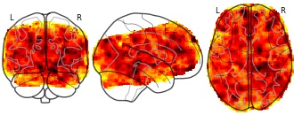
Collection description
Group level statistical maps for the slot-machine task reported in the associated publication
Subject species
homo sapiens
Modality
fMRI-BOLD
Analysis level
group
Cognitive paradigm (task)
gambling task
Map type
Z
- o
Computational stability data of SiB2Mo5from Density Functional Theory...
- oqmd.org
Updated May 30, 2022+ more versionsShareFacebookTwitterEmailClick to copy linkLink copiedCiteThe Open Quantum Materials Database (2022). Computational stability data of SiB2Mo5 from Density Functional Theory calculations [Dataset]. https://oqmd.org/materials/composition/SiB2Mo5Dataset updatedMay 30, 2022Dataset authored and provided byThe Open Quantum Materials DatabaseLicenseAttribution 4.0 (CC BY 4.0)https://creativecommons.org/licenses/by/4.0/
License information was derived automaticallyVariables measuredStability, Composition, Decomposition EnergyMeasurement techniqueComputational, Density Functional TheoryDescriptionThis composition appears in the B-Mo-Si region of phase space. It's relative stability is shown in the B-Mo-Si phase diagram (left). The relative stability of all other phases at this composition (and the combination of other stable phases, if no compound at this composition is stable) is shown in the relative stability plot (right)
WFS INSPIRE HH Transport Networks HH-SIB
- data.subak.org
wfsUpdated Feb 15, 2023+ more versionsShareFacebookTwitterEmailClick to copy linkLink copiedCiteEuropean Commission (2023). WFS INSPIRE HH Transport Networks HH-SIB [Dataset]. https://data.subak.org/dataset/wfs-inspire-hh-transport-networks-hh-sibwfsAvailable download formatsDataset updatedFeb 15, 2023DescriptionThis WebFeatureService (WFS) contains the INSPIRE data of the HH-SIB in the INSPIRE target model.
For a more detailed description of the data and data responsibility, please use the reference to the data record description.
- d
Data from: Sib-mating enhances fitness in a haplodiploid beetle
- datadryad.org
- data.niaid.nih.gov
- +1more
zipUpdated Oct 20, 2022ShareFacebookTwitterEmailClick to copy linkLink copiedCiteYael Lubin; Aviad Moncaz; Rachel Ben-Shlomo; Adi Kliot; Ally Harari (2022). Sib-mating enhances fitness in a haplodiploid beetle [Dataset]. http://doi.org/10.5061/dryad.n02v6wx1dzipAvailable download formatsUnique identifierhttps://doi.org/10.5061/dryad.n02v6wx1dDataset updatedOct 20, 2022Dataset provided byDryadAuthorsYael Lubin; Aviad Moncaz; Rachel Ben-Shlomo; Adi Kliot; Ally HarariTime period covered2022DescriptionExcel
- d
Data from: Exploration of genetic architecture through sib-ship...
- datadryad.org
- data.niaid.nih.gov
- +1more
zipUpdated Sep 13, 2018ShareFacebookTwitterEmailClick to copy linkLink copiedCiteJaroslav Klápště; Mari Suontama; Emily Telfer; Natalie Graham; Charlie Low; Toby Stovold; Russel McKinley; Heidi Dungey (2018). Exploration of genetic architecture through sib-ship reconstruction in advanced breeding population of Eucalyptus nitens [Dataset]. http://doi.org/10.5061/dryad.q62j0zipAvailable download formatsUnique identifierhttps://doi.org/10.5061/dryad.q62j0Dataset updatedSep 13, 2018Dataset provided byDryadAuthorsJaroslav Klápště; Mari Suontama; Emily Telfer; Natalie Graham; Charlie Low; Toby Stovold; Russel McKinley; Heidi DungeyTime period covered2018Area coveredNew ZealandDescriptionPedigreePedigree for the studied populationPhenotype fileFile containing phenotypic data for the studied populationPhen_for_Publication.csvGenotypic dataData folder containing genotypes and their associated qualitative scores (GenTrain score and GenCall)GenData.zip
Data from: Diversidad potencial del Reino Fungi (macrohongos y líquenes) en...
- gbif.org
- es.bionomia.net
- +5more
Updated Dec 19, 2024ShareFacebookTwitterEmailClick to copy linkLink copiedCiteLaura Sánchez-Jardón; Roberto Uribe-Paredes; Julio Águila; Diego Álvarez; Cristian Aldea; Eduardo Velázquez Martín; Víctor Raimilla Almonacid; Dinelly Soto; Pía Osses Sandoval; Paloma Manubens Coda; Laura del Rio-Hortega Balsalobre; Mario Mingarro; Sebastián Zambrano; Belén Acosta Gallo; Noemi Núñez Cea; Laura Sánchez-Jardón; Roberto Uribe-Paredes; Julio Águila; Diego Álvarez; Cristian Aldea; Eduardo Velázquez Martín; Víctor Raimilla Almonacid; Dinelly Soto; Pía Osses Sandoval; Paloma Manubens Coda; Laura del Rio-Hortega Balsalobre; Mario Mingarro; Sebastián Zambrano; Belén Acosta Gallo; Noemi Núñez Cea (2024). Diversidad potencial del Reino Fungi (macrohongos y líquenes) en el Sistema de Información en Biodiversidad para Aysén (SIB-Aysén), Chile [Dataset]. http://doi.org/10.15468/fuwe8eUnique identifierhttps://doi.org/10.15468/fuwe8eDataset updatedDec 19, 2024Dataset provided byGlobal Biodiversity Information Facilityhttps://www.gbif.org/
Universidad de MagallanesAuthorsLaura Sánchez-Jardón; Roberto Uribe-Paredes; Julio Águila; Diego Álvarez; Cristian Aldea; Eduardo Velázquez Martín; Víctor Raimilla Almonacid; Dinelly Soto; Pía Osses Sandoval; Paloma Manubens Coda; Laura del Rio-Hortega Balsalobre; Mario Mingarro; Sebastián Zambrano; Belén Acosta Gallo; Noemi Núñez Cea; Laura Sánchez-Jardón; Roberto Uribe-Paredes; Julio Águila; Diego Álvarez; Cristian Aldea; Eduardo Velázquez Martín; Víctor Raimilla Almonacid; Dinelly Soto; Pía Osses Sandoval; Paloma Manubens Coda; Laura del Rio-Hortega Balsalobre; Mario Mingarro; Sebastián Zambrano; Belén Acosta Gallo; Noemi Núñez CeaLicenseAttribution-NonCommercial 4.0 (CC BY-NC 4.0)https://creativecommons.org/licenses/by-nc/4.0/
License information was derived automaticallyArea coveredDescriptionSe reportan 1263 registros del Reino Fungi presentes en la región de Aysén recopilados a partir de bibliografía publicada (revistas especializadas, publicaciones divulgativas y documentos técnicos). 385 de ellos se encuentran sin información en sus coordenadas. Corresponden a 251 taxa de macrohongos y 367 de líquenes. Cuando se especifica en la referencia bibliográfica, se describe el tipo de sustrato (hábitat) en el que crecen. Esta recopilación se inició con el proyecto FIC del Gobierno Regional de Aysén "Sistema de Información sobre Biodiversidad para Aysén (BIP 30346481-0)", se continuó con "Hongusto: innovación social en torno a los hongos comestibles silvestres y cultivados de la región de Aysén (CORFO 15IS-46635)" y con ""Prototipo de Laboratorio Abierto de Ceincias Subantárticas (BIP 40000521-0). Eventualmente será complementada con las observaciones de ciudadanos asociadas al Sistema de Información en Biodiversidad para Aysén (SIB-Aysén).

Not seeing a result you expected?
Learn how you can add new datasets to our index.
FacebookTwitterhttps://whoisdatacenter.com/terms-of-use/https://whoisdatacenter.com/terms-of-use/
Explore historical ownership and registration records by performing a reverse Whois lookup for the email address informatique@sib-org.com..